Weather changes often seem sudden—a warm day turns cool, clouds roll in, and rain begins. Behind these shifts are air masses and frontal systems, two fundamental concepts in Earth science that control much of our day-to-day weather.
Understanding how air masses interact and how fronts form helps explain temperature changes, precipitation, and storm development.
What Is an Air Mass?
An air mass is a large body of air with relatively uniform temperature and humidity throughout.
Air masses form over specific regions called source regions, where they take on the characteristics of the surface below.
Common Source Regions
- Oceans (moist air)
- Continents (dry air)
- Polar regions (cold air)
- Tropical regions (warm air)
Types of Air Masses
Air masses are classified based on moisture and temperature.
By Moisture
- Maritime (m): Moist air from oceans
- Continental (c): Dry air from land
By Temperature
- Tropical (T): Warm or hot
- Polar (P): Cold
- Arctic (A): Very cold
Common Air Mass Types
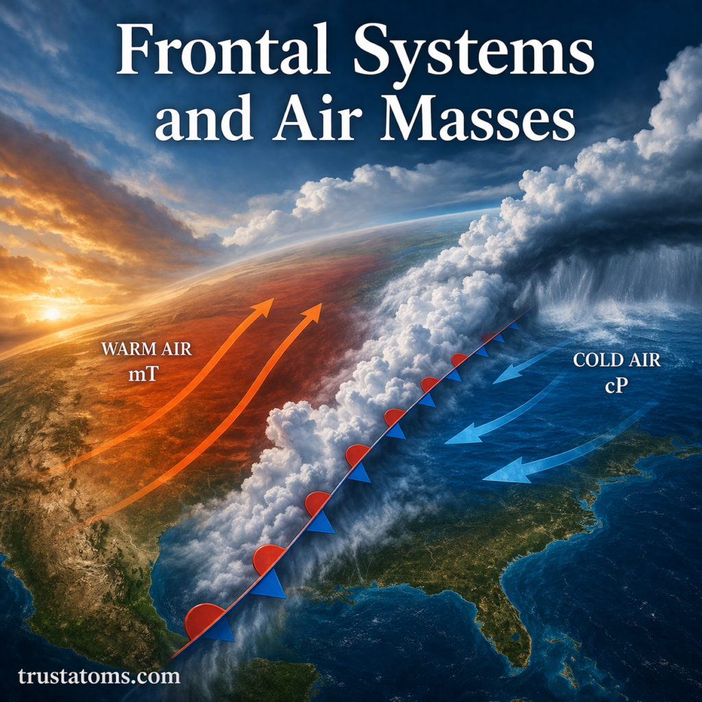
- mT (Maritime Tropical): Warm and humid
- cT (Continental Tropical): Hot and dry
- mP (Maritime Polar): Cool and moist
- cP (Continental Polar): Cold and dry
Each type influences weather differently depending on where it moves.
What Is a Front?
A front is the boundary between two different air masses.
When air masses with different temperatures and moisture levels meet, they do not mix easily. Instead, they form a transition zone where weather changes often occur.
Types of Frontal Systems
There are four main types of fronts, each producing distinct weather patterns.
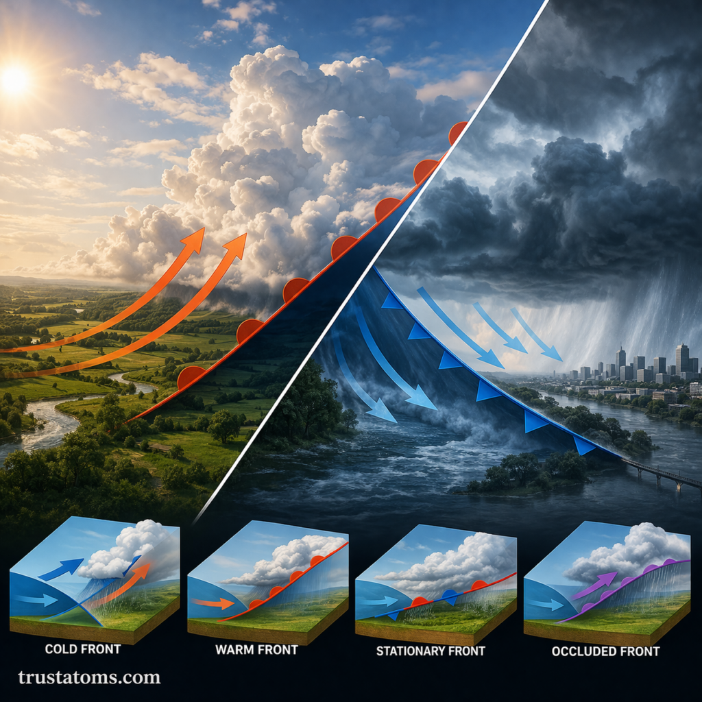
1. Cold Front
A cold front occurs when a cold air mass moves toward and replaces a warmer air mass.
Key Characteristics
- Cold, dense air pushes under warm air
- Warm air is forced to rise quickly
- Often produces:
- Thunderstorms
- Heavy rain
- Sudden temperature drops
Cold fronts typically move quickly and can cause dramatic weather changes.
2. Warm Front
A warm front forms when a warm air mass moves over a colder air mass.
Key Characteristics
- Warm air rises gradually over cold air
- Clouds form in layers
- Often produces:
- Light to moderate, steady precipitation
- Gradual temperature increases
Warm fronts usually move more slowly than cold fronts.
3. Stationary Front
A stationary front occurs when two air masses meet but neither advances.
Key Characteristics
- Little to no movement
- Prolonged cloudiness
- Extended periods of rain or drizzle
These fronts can linger for days, leading to persistent weather conditions.
4. Occluded Front
An occluded front forms when a cold front overtakes a warm front.
Key Characteristics
- Complex interaction of three air masses
- Warm air is lifted off the ground
- Often produces:
- Widespread precipitation
- Cooler temperatures
Occluded fronts are common in mature storm systems.
How Fronts Affect Weather
Frontal systems are responsible for many everyday weather changes.
Common Effects
- Temperature shifts
- Cloud formation
- Precipitation (rain, snow, or storms)
- Wind changes
The type and intensity of weather depend on how quickly the front moves and the characteristics of the air masses involved.
Air Mass Movement and Weather Patterns
Air masses are constantly moving due to global wind patterns.
Factors Influencing Movement
- Pressure systems (high and low pressure)
- Jet streams
- Earth’s rotation
As air masses move, they carry their temperature and moisture properties with them, shaping regional weather.
Fronts and Storm Development
Frontal boundaries are often the starting point for storm formation.
Why Storms Form Along Fronts
- Rising air cools and condenses
- Clouds develop
- Instability can lead to severe weather
Cold fronts, in particular, are known for triggering thunderstorms due to rapid uplift.
Why Air Masses and Fronts Matter
These systems are essential for understanding weather and climate:
- Help explain daily weather changes
- Influence regional climates
- Play a role in storm formation
- Aid meteorologists in forecasting
Without air mass interactions, weather would be far less dynamic.
Final Thoughts
Frontal systems and air masses are the building blocks of weather. From gentle rain to powerful storms, many atmospheric events begin with the interaction between different air masses.
By understanding how fronts form and move, you gain a clearer picture of how weather evolves—and why conditions can change so quickly.