Supercontinents and Continental Cycles

Illustration showing supercontinents and continental cycles with stages from Pangaea formation to modern continents.
Supercontinent cycle showing the formation, breakup, and reconfiguration of continents over time. trustatoms.com.

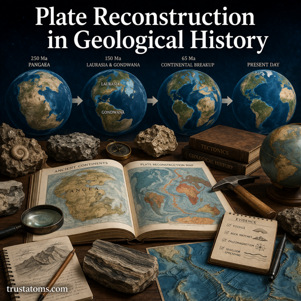
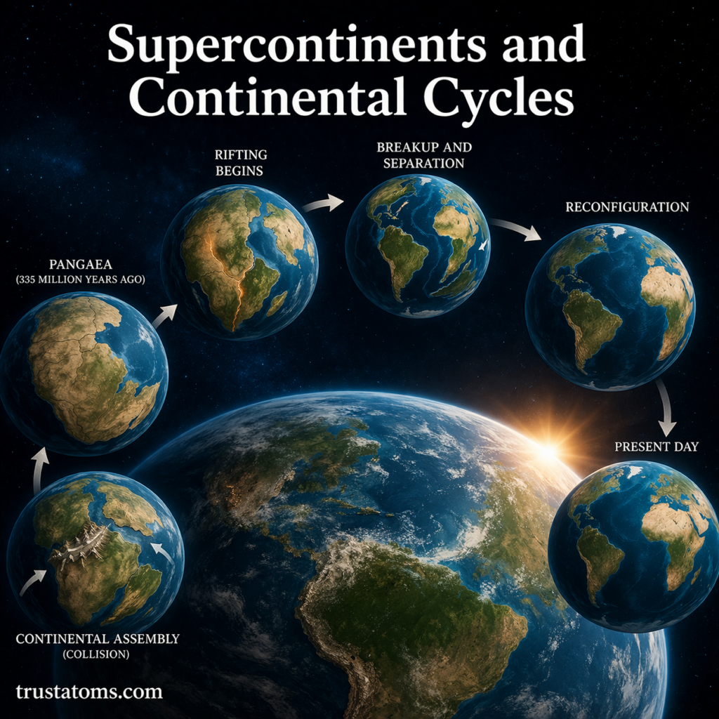
Earth’s continents may seem fixed, but over geologic time they are constantly moving, colliding, and separating. This long-term process is known as the continental cycle (or supercontinent cycle), and it has shaped the planet’s surface for billions of years.

At certain points in this cycle, most of Earth’s landmass joins together to form a supercontinent—a single massive landmass that dramatically influences climate, oceans, and life.

Continue reading “Supercontinents and Continental Cycles”

Plate Reconstruction in Geological History

Illustration showing plate reconstruction in geological history with continental drift from Pangaea to present day.
Plate reconstruction showing the movement of continents from Pangaea to present day. trustatoms.com.

Plate reconstruction is a scientific method used to piece together the past positions and movements of Earth’s tectonic plates. By analyzing geological, paleontological, and geophysical evidence, scientists can “rewind” the planet’s history and understand how continents and oceans have shifted over millions—even billions—of years.

This process helps explain the formation of mountains, oceans, earthquakes, and even patterns of life on Earth.

Continue reading “Plate Reconstruction in Geological History”

Tsunami Formation and Seafloor Movement

Illustration showing tsunami formation caused by seafloor movement with tectonic plate displacement and ocean wave buildup.
Tsunami formation illustrated through seafloor movement and tectonic plate displacement. trustatoms.com.

Tsunamis are among the most powerful and destructive natural events on Earth. Unlike regular ocean waves caused by wind, tsunamis are triggered by sudden movements of the seafloor, displacing massive amounts of water in a short time.

Understanding how tsunamis form—and how seafloor movement drives them—helps explain why these waves can travel across entire oceans and cause devastating coastal impacts.

Continue reading “Tsunami Formation and Seafloor Movement”

Volcanic Eruption Patterns

Illustration showing different volcanic eruption types including effusive, Strombolian, Vulcanian, and Plinian eruptions.
Illustration of volcanic eruption patterns, showing different eruption styles based on magma composition and gas pressure. trustatoms.com

Volcanoes are among the most powerful and dynamic features on Earth. While eruptions may appear unpredictable, scientists have identified clear patterns in how volcanoes behave. These eruption patterns depend on factors such as magma composition, gas content, and tectonic setting.

Understanding volcanic eruption patterns helps scientists forecast activity, reduce risks, and better understand Earth’s internal processes.

Continue reading “Volcanic Eruption Patterns”

Earthquake Zones and Plate Interaction

Illustration of global earthquake zones along tectonic plate boundaries showing plate movement and seismic activity.
Illustration showing earthquake zones along tectonic plate boundaries and how plate interactions cause seismic activity. trustatoms.com

Earthquakes are one of the most powerful natural forces on our planet. While they may seem sudden and unpredictable, most earthquakes occur in specific regions known as earthquake zones—areas closely linked to the movement and interaction of tectonic plates.

Understanding how plate interactions create earthquake zones helps explain where earthquakes are most likely to occur and why they happen in the first place.

Continue reading “Earthquake Zones and Plate Interaction”

Plate Motion Measurement Using GPS

Illustration of GPS station measuring tectonic plate motion with satellite signals and ground movement arrows.
Illustration showing how GPS technology measures tectonic plate motion using satellites and ground-based stations. trustatoms.com

The Earth’s surface is constantly in motion, even though we don’t feel it. Massive sections of the crust, known as tectonic plates, move slowly over time—sometimes only a few centimeters per year.

Today, scientists can measure this movement with incredible precision using Global Positioning System (GPS) technology. This has revolutionized our understanding of plate tectonics, earthquakes, and Earth’s dynamic behavior.

Continue reading “Plate Motion Measurement Using GPS”

Delta Formation and Sediment Deposition

River delta illustration showing distributary channels, sediment deposition, and land formation at a river mouth.
Illustration of delta formation as rivers deposit sediment and create branching distributary channels. trustatoms.com

River deltas are some of the most fertile and dynamic landforms on Earth. Found where rivers meet larger bodies of water such as oceans, seas, or lakes, deltas are created through the gradual process of sediment deposition.

These landscapes are constantly changing, shaped by the balance between river flow, sediment supply, and wave or tidal activity. Understanding how deltas form helps explain not only Earth’s surface processes but also the development of ecosystems and human settlements.

Continue reading “Delta Formation and Sediment Deposition”

Coastal Landforms and Wave Action

Coastal landscape illustration showing sea cliffs, sea arch, sea stack, beach, and wave action shaping the shoreline.
Illustration of coastal landforms shaped by wave action, including cliffs, arches, stacks, and beaches. trustatoms.com

Coastal landforms are constantly shaped and reshaped by the powerful forces of waves, tides, and currents. Along shorelines around the world, wave action plays a central role in carving cliffs, forming beaches, and creating dramatic features like arches and sea stacks.

Understanding how waves interact with land helps explain why coastlines look the way they do—and why they are always changing.

Continue reading “Coastal Landforms and Wave Action”

Karst Landscapes and Limestone Erosion

Karst landscape illustration showing sinkholes, limestone caves, underground river, and erosion processes.
Illustration of karst landscapes formed by limestone erosion, featuring caves, sinkholes, and underground water systems. trustatoms.com

Karst landscapes are some of the most fascinating and unique landforms on Earth. Characterized by caves, sinkholes, disappearing rivers, and underground drainage systems, these environments are shaped primarily by the slow but powerful process of limestone erosion.

Understanding how karst landscapes form not only reveals the hidden dynamics of Earth’s surface but also highlights the importance of water in shaping the natural world.

Continue reading “Karst Landscapes and Limestone Erosion”

Desert Landforms and Wind Erosion

Illustration of desert landforms including sand dunes, yardangs, desert pavement, and ventifacts shaped by wind erosion.
A detailed desert landscape showing how wind erosion shapes dunes, rocks, and surface features over time. trustatoms.com

Deserts are often seen as barren and lifeless, but they are some of the most dynamic landscapes on Earth. Shaped primarily by wind and limited water, deserts feature unique landforms created through erosion, transportation, and deposition.

Understanding desert landforms and wind erosion reveals how even the harshest environments are constantly changing over time.

Continue reading “Desert Landforms and Wind Erosion”