Plate reconstruction is a scientific method used to piece together the past positions and movements of Earth’s tectonic plates. By analyzing geological, paleontological, and geophysical evidence, scientists can “rewind” the planet’s history and understand how continents and oceans have shifted over millions—even billions—of years.
This process helps explain the formation of mountains, oceans, earthquakes, and even patterns of life on Earth.
What Is Plate Reconstruction?
Plate reconstruction involves mapping the historical positions of tectonic plates through time. Scientists use a combination of data and modeling techniques to determine where continents were located in the past.
The goal is to answer questions like:
- Where were today’s continents millions of years ago?
- How did supercontinents form and break apart?
- What forces drove plate movements over time?
By reconstructing plate positions, researchers gain insights into Earth’s dynamic evolution.
Why Plate Reconstruction Matters
Understanding past plate movements is essential for several reasons:
Geological Insights
- Explains mountain formation (e.g., Himalayas from plate collision)
- Reveals how ocean basins opened and closed
- Helps identify ancient volcanic and earthquake zones
Climate and Environmental History
- Tracks how continents moved through different climate zones
- Explains past ice ages and warming periods
- Influences ocean currents and atmospheric circulation
Evolution of Life
- Shows how species spread across continents
- Explains fossil similarities across distant regions
- Helps reconstruct ancient ecosystems
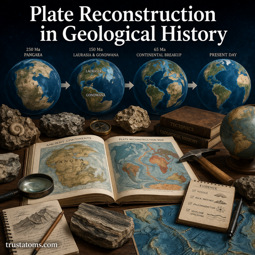
Key Evidence Used in Plate Reconstruction
Scientists rely on multiple lines of evidence to reconstruct plate movements.
Fossil Correlation
Identical fossils found on separate continents suggest those landmasses were once connected.
- Example: Mesosaurus fossils found in both South America and Africa
Rock and Mountain Patterns
Matching rock formations and mountain ranges across continents indicate past connections.
- The Appalachian Mountains in North America align with ranges in Europe and Africa
Paleomagnetism
Earth’s magnetic field leaves a signature in rocks as they form.
- Magnetic minerals align with the planet’s magnetic field
- These alignments reveal the latitude where rocks formed
- Patterns of magnetic reversal help date seafloor spreading
Seafloor Spreading
New ocean crust forms at mid-ocean ridges and moves outward.
- Younger rocks are found near ridges
- Older rocks are farther away
- Symmetrical magnetic patterns confirm plate movement
The Role of Supercontinents
A major focus of plate reconstruction is understanding supercontinents—large landmasses formed by the merging of multiple continents.
Pangaea
- Existed about 335 to 175 million years ago
- Included nearly all Earth’s landmasses
- Eventually broke apart into today’s continents
Earlier Supercontinents
Scientists have identified even older supercontinents, such as:
- Rodinia (around 1 billion years ago)
- Columbia (or Nuna, about 1.8 billion years ago)
These cycles of assembly and breakup are known as the supercontinent cycle.
Tools and Techniques in Modern Plate Reconstruction
Advances in technology have greatly improved reconstruction accuracy.
Computer Modeling
- Simulates plate motion over time
- Integrates geological and geophysical data
- Allows visualization of continental drift
GPS Measurements
- Tracks current plate movements in real time
- Confirms rates of motion (a few centimeters per year)
Ocean Drilling Data
- Provides samples of seafloor rock
- Helps determine age and composition
- Supports seafloor spreading models
Satellite Imaging
- Maps Earth’s surface with high precision
- Identifies tectonic features and boundaries
Challenges in Plate Reconstruction
Reconstructing Earth’s history is complex and involves uncertainties.
Incomplete Geological Record
- Older rocks are often destroyed by erosion or subduction
- Ocean crust rarely survives beyond 200 million years
Uncertain Plate Boundaries
- Ancient plate boundaries may not be preserved
- Requires interpretation based on limited evidence
Model Limitations
- Different models may produce slightly different reconstructions
- Continuous refinement is needed as new data emerges
How Plate Reconstruction Explains Today’s Earth
Plate reconstruction connects past events to present-day geography.
- Continents like South America and Africa fit together like puzzle pieces
- Mountain ranges reveal past collisions
- Earthquake zones align with plate boundaries
- Ocean ridges mark areas of active crust formation
Understanding these patterns helps scientists predict geological activity and better understand Earth’s future.
Key Takeaways
- Plate reconstruction maps the historical movement of Earth’s tectonic plates
- Evidence includes fossils, rock formations, paleomagnetism, and seafloor data
- Supercontinents like Pangaea played a major role in Earth’s history
- Modern tools like GPS and computer modeling improve accuracy
- The process helps explain geology, climate, and biological evolution
Final Thoughts
Plate reconstruction offers a powerful window into Earth’s deep past. By piecing together fragments of geological evidence, scientists can recreate ancient worlds and understand the forces that shaped our planet.
As technology advances and new discoveries are made, our picture of Earth’s history continues to become clearer—revealing a dynamic planet constantly in motion.