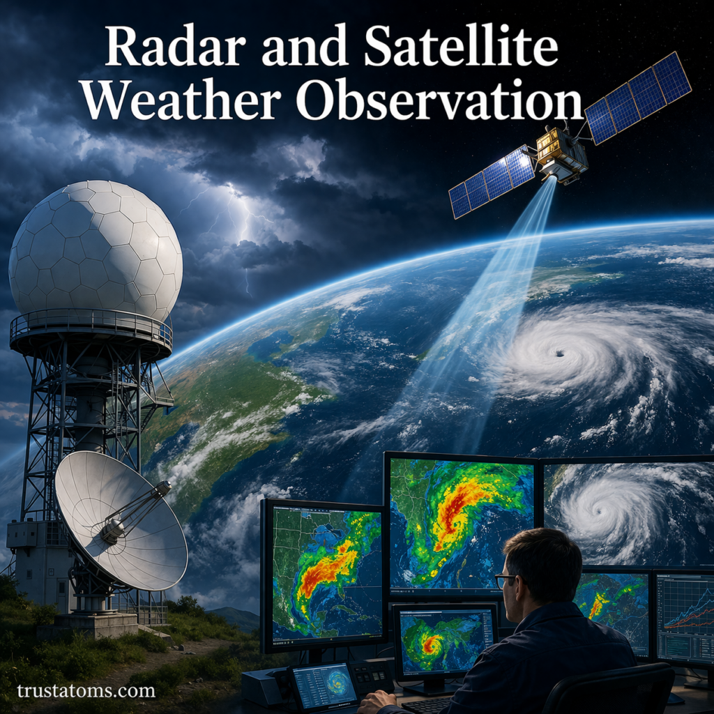
Modern weather forecasting relies heavily on advanced observation systems. Among the most important tools are radar and satellite technologies, which allow meteorologists to monitor the atmosphere in real time.
These systems provide critical data on storms, clouds, precipitation, and large-scale weather patterns—helping improve forecast accuracy and early warning systems.
What Is Weather Observation?
Weather observation involves collecting real-time data about atmospheric conditions.
This includes:
- Temperature
- Humidity
- Wind speed and direction
- Cloud cover
- Precipitation
Radar and satellites play a key role by providing continuous, large-scale coverage that ground-based instruments alone cannot achieve.
Radar in Weather Observation
Radar (Radio Detection and Ranging) is used to detect precipitation and track storms.
How Weather Radar Works
- Radar systems send out pulses of radio waves
- These waves hit precipitation particles (rain, snow, hail)
- The waves bounce back to the radar receiver
- The system analyzes the returned signal
This allows meteorologists to determine:
- Location of precipitation
- Intensity of rainfall
- Movement and direction of storms
Doppler Radar Technology
Doppler radar adds another layer of detail by measuring motion.
What Doppler Radar Detects
- Wind speed and direction
- Rotation within storms
- Potential tornado formation
It works by detecting changes in the frequency of returned radio waves, known as the Doppler effect.
Why It Matters
- Helps identify severe weather early
- Tracks storm development in real time
- Improves warning systems for dangerous conditions
Interpreting Radar Images
Radar images are often displayed using color-coded maps.
Common Color Meanings
- Green – light precipitation
- Yellow – moderate rain
- Red – heavy rain or storms
- Purple – very intense precipitation or hail
Meteorologists analyze these patterns to understand storm strength and movement.
Satellite Weather Observation
Weather satellites provide a global view of Earth’s atmosphere.
Unlike radar, which focuses on local precipitation, satellites observe large-scale weather systems.
Types of Weather Satellites
1. Geostationary Satellites
- Orbit above the same point on Earth
- Provide continuous monitoring
- Ideal for tracking storms and cloud movement
2. Polar-Orbiting Satellites
- Move from pole to pole
- Provide detailed global coverage
- Capture high-resolution data
What Satellites Measure
Satellites collect a wide range of atmospheric data:
- Cloud formation and movement
- Surface and atmospheric temperatures
- Water vapor levels
- Storm development
- Ocean and land conditions
This data is essential for understanding global weather patterns.
Types of Satellite Imagery
Different imaging techniques reveal different aspects of the atmosphere.
Visible Imagery
- Shows clouds as seen by the human eye
- Best used during daylight
- Helps identify cloud shapes and coverage
Infrared Imagery
- Measures heat emitted by objects
- Works day and night
- Helps determine cloud height and temperature
Water Vapor Imagery
- Tracks moisture in the atmosphere
- Highlights areas of dry and moist air
- Useful for identifying developing weather systems
Radar vs Satellite: Key Differences
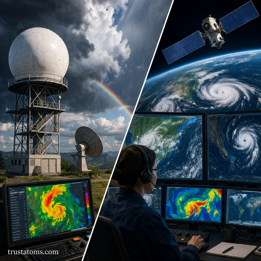
While both tools are essential, they serve different purposes.
Radar
- Focuses on precipitation
- Provides high-detail local data
- Tracks storm intensity and movement
Satellite
- Covers large geographic areas
- Observes cloud patterns and global systems
- Provides continuous monitoring from space
Together, they offer a complete picture of atmospheric conditions.
How These Tools Improve Forecasting
Radar and satellite data are integrated into weather models to improve predictions.
Key Benefits
- Early detection of severe weather
- More accurate storm tracking
- Better long-term forecasting
- Improved public safety warnings
These technologies allow meteorologists to respond quickly to changing conditions.
Real-World Applications
1. Severe Weather Warnings
- Detecting tornadoes and thunderstorms
- Issuing alerts for hurricanes and storms
2. Aviation Safety
- Avoiding turbulence and storms
- Planning safe flight routes
3. Disaster Preparedness
- Monitoring floods and extreme weather
- Supporting emergency response
4. Climate Monitoring
- Tracking long-term weather trends
- Observing changes in global systems
Key Takeaways
- Radar detects precipitation and storm movement
- Doppler radar measures wind and storm rotation
- Satellites provide large-scale, global atmospheric data
- Different satellite imagery types reveal different weather features
- Combining radar and satellite data improves forecasting accuracy
Final Thoughts
Radar and satellite weather observation have transformed how we understand and predict the atmosphere. By providing real-time, detailed insights into both local storms and global patterns, these technologies form the backbone of modern meteorology.
As technology continues to advance, weather observation systems will become even more precise—helping protect lives, improve forecasts, and deepen our understanding of Earth’s dynamic atmosphere.