Rivers are among the most powerful natural forces shaping Earth’s surface. Over time, flowing water cuts through rock and soil, creating valleys, transporting sediments, and forming complex landscapes.
Understanding river systems and valley formation helps explain how landscapes evolve, how ecosystems develop, and how water moves across the planet.
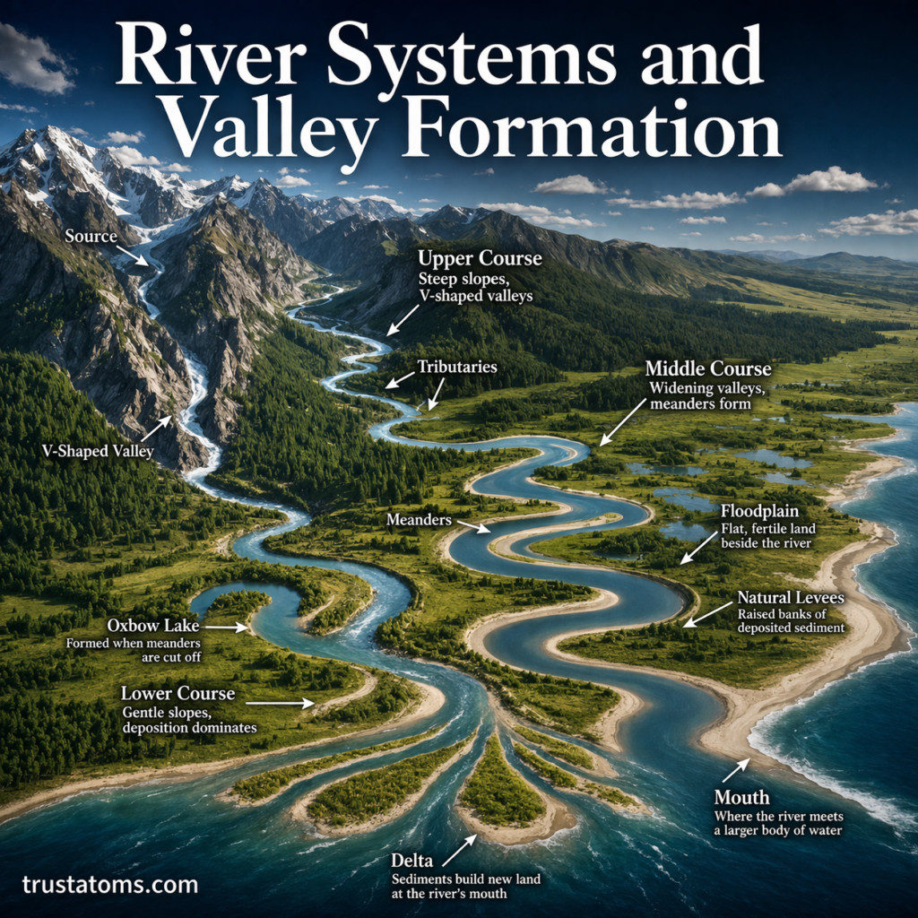
What Is a River System?
A river system is a network of flowing water that includes a main river and its smaller tributaries.
Key components of a river system include:
- Source – the starting point of a river (often in mountains or highlands)
- Tributaries – smaller streams that feed into the main river
- Channel – the path the river follows
- Floodplain – flat land alongside the river that may flood
- Mouth – where the river empties into a larger body of water
Together, these elements form a connected system that drains a specific area of land.
The Water Cycle and Rivers
Rivers are part of the continuous movement of water on Earth, known as the water cycle.
Water enters river systems through:
- Rainfall
- Snowmelt
- Groundwater flow
This constant supply keeps rivers flowing and allows them to shape the landscape over time.
How Rivers Shape the Land
Rivers shape Earth’s surface through three main processes:
Erosion
- Rivers cut into the land and remove material
- Strongest in upper courses where slopes are steep
- Creates valleys and channels
Transportation
- Sediments are carried downstream
- Includes sand, gravel, and dissolved materials
Deposition
- Occurs when the river loses energy
- Sediments are dropped and build up landforms
Stages of a River
Rivers change as they flow from source to mouth. These stages influence how valleys form.
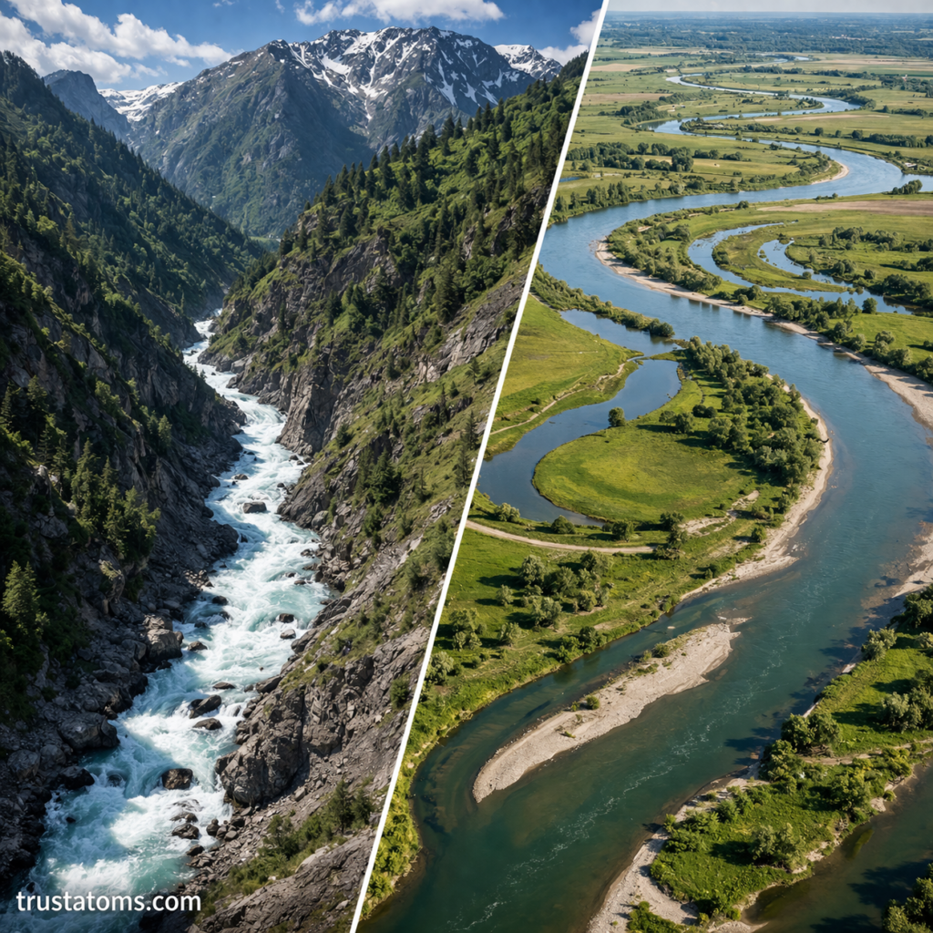
Upper Course
- Steep gradients and fast flow
- Dominated by vertical erosion
- Creates narrow, V-shaped valleys
Middle Course
- Gentler slopes
- Increased lateral erosion
- Valleys widen and meanders form
Lower Course
- Very gentle slopes
- Deposition becomes dominant
- Wide floodplains and deltas form
Formation of Valleys
River valleys are formed primarily through erosion over long periods.
V-Shaped Valleys
- Found in upper courses
- Steep sides and narrow floors
- Created by downward erosion
Wide Valleys
- Found in middle and lower courses
- Formed by lateral erosion
- Broader and flatter
Meanders and Oxbow Lakes
As rivers flow across flatter land, they begin to curve.
Meanders
- Bends in a river
- Form due to uneven erosion and deposition
- Outer banks erode, inner banks build up sediment
Oxbow Lakes
- Form when a meander is cut off
- Creates a crescent-shaped lake
- Shows how rivers change course over time
Floodplains and Natural Levees
Rivers also shape surrounding land through flooding.
Floodplains
- Flat areas beside rivers
- Formed by repeated deposition of sediments
- Often fertile and used for agriculture
Natural Levees
- Raised banks along the river
- Formed by heavier sediments dropping near the channel
Deltas and River Mouths
At the end of a river’s journey, deposition creates distinct features.
Deltas
- Form where rivers enter still water (oceans or lakes)
- Sediments build up into fan-shaped landforms
- Often rich in biodiversity
Estuaries
- Where freshwater mixes with saltwater
- Influenced by tides
- Important ecosystems
Factors Affecting River Systems
Several factors influence how rivers behave and shape valleys:
- Climate (rainfall and temperature)
- Slope of the land
- Type of rock and soil
- Vegetation cover
- Human activity (dams, land use)
These factors determine the speed, size, and shape of river systems.
Human Impact on River Systems
Humans have significantly altered river systems:
- Dams control water flow and create reservoirs
- Urban development changes drainage patterns
- Pollution affects water quality
- Agriculture modifies floodplains
While rivers are natural systems, human activity can greatly influence their behavior.
Evidence of River Activity
Geographers and scientists study river systems through:
- Channel patterns and shapes
- Sediment deposits
- Valley structures
- Satellite imagery
- Field observations
These observations help explain how landscapes have changed over time.
Why River Systems Matter
River systems are essential for both natural and human environments:
- Provide freshwater resources
- Support ecosystems and wildlife
- Shape landscapes and soils
- Enable transportation and agriculture
They are vital to life and the functioning of Earth’s surface systems.
Common Misconceptions
Rivers Always Follow the Same Path
Rivers can change course over time due to erosion and flooding.
Valleys Form Quickly
Valley formation is a slow process that takes thousands to millions of years.
Rivers Only Erode
Rivers both erode and deposit material, shaping land in multiple ways.
Final Thoughts
River systems and valley formation illustrate the dynamic nature of Earth’s surface. Through erosion, transport, and deposition, rivers carve valleys, build landforms, and continuously reshape the landscape.
By understanding how rivers work, we gain insight into one of the most important natural processes on Earth—and the forces that shape the world around us.