River Systems and Valley Formation

Illustration of a river system showing source, tributaries, meanders, floodplains, and delta formation across a landscape.
A detailed river system diagram showing how flowing water shapes valleys, meanders, floodplains, and deltas. trustatoms.com

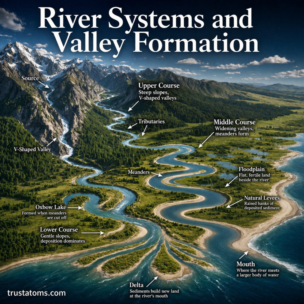
Rivers are among the most powerful natural forces shaping Earth’s surface. Over time, flowing water cuts through rock and soil, creating valleys, transporting sediments, and forming complex landscapes.

Understanding river systems and valley formation helps explain how landscapes evolve, how ecosystems develop, and how water moves across the planet.

Continue reading “River Systems and Valley Formation”

Glacial Landforms and Ice Movement

Illustration of glacial landforms including U-shaped valley, moraines, drumlins, and ice movement through a mountain landscape.
A detailed glacier landscape showing how ice movement shapes landforms like valleys, moraines, and drumlins. trustatoms.com

Glaciers are powerful natural forces that shape Earth’s surface over thousands to millions of years. These massive, slow-moving bodies of ice carve valleys, transport rock, and create unique landforms that tell the story of past climates.

Understanding glacial landforms and ice movement helps explain how landscapes evolve and how ice has influenced regions across the world.

Continue reading “Glacial Landforms and Ice Movement”

Folding and Faulting in Earth’s Crust

Illustration showing folded rock layers and fault lines demonstrating folding and faulting processes in Earth’s crust.
A geological cross-section illustrating how folding bends rock layers and faulting breaks and shifts the crust. trustatoms.com

Earth’s crust is constantly under stress from tectonic forces. Over time, these forces cause rocks to bend, break, and shift—processes known as folding and faulting.

These geological processes are responsible for shaping mountains, valleys, and many of the landscapes we see today. They also play a major role in earthquakes and the overall structure of Earth’s surface.

Continue reading “Folding and Faulting in Earth’s Crust”

Continental Collision Processes

Illustration of continental collision showing two tectonic plates converging and forming mountains through crustal thickening.
A cross-section diagram showing how continental plates collide and form mountain ranges through compression and uplift. trustatoms.com

Continental collision is one of the most powerful geological processes on Earth. It occurs when two continental tectonic plates move toward each other and collide, reshaping the planet’s surface on a massive scale.

Unlike oceanic plates, continental plates are thick and buoyant. When they collide, neither plate easily sinks into the mantle. Instead, the crust crumples, folds, and rises—creating some of the world’s largest mountain ranges.

Continue reading “Continental Collision Processes”

Earth’s Major Tectonic Plates

Illustration of Earth’s major tectonic plates labeled on a global map showing plate boundaries and continents.
A simplified global diagram showing Earth’s major tectonic plates and their boundaries. trustatoms.com

Earth’s surface may look solid and unchanging, but it is actually broken into massive pieces called tectonic plates. These plates are constantly moving—albeit very slowly—shaping the continents, oceans, mountains, and even influencing earthquakes and volcanic activity.

Understanding Earth’s major tectonic plates helps explain why natural disasters occur, how continents drift over time, and how our planet continues to evolve.

Continue reading “Earth’s Major Tectonic Plates”

Hotspots and Mantle Plumes

Illustration showing mantle plume rising beneath a tectonic plate forming a hotspot and volcanic island chain.
Illustration of hotspots and mantle plumes creating volcanic island chains as tectonic plates move. trustatoms.com.

Hotspots and mantle plumes are powerful geological phenomena that help explain volcanic activity far from tectonic plate boundaries. Unlike most volcanoes, which form along plate edges, hotspots can occur in the middle of plates—creating chains of volcanoes and islands across the ocean floor.

From the Hawaiian Islands to Yellowstone, these features reveal deep connections between Earth’s surface and its interior.

Continue reading “Hotspots and Mantle Plumes”

Ocean Trenches and Deep-Sea Topography

Illustration of ocean trenches and deep-sea topography showing abyssal plains, seamounts, and mid-ocean ridges beneath the ocean surface.
Illustration of ocean trenches and deep-sea features including ridges, plains, and seamounts. trustatoms.com.

The deep ocean is one of the least explored regions on Earth, yet it contains some of the planet’s most dramatic landscapes. Among these features, ocean trenches stand out as the deepest and most extreme environments, plunging miles below the ocean surface.

Understanding ocean trenches and deep-sea topography helps scientists uncover how Earth’s crust behaves, how plate tectonics operates beneath the oceans, and how life survives in extreme conditions.

Continue reading “Ocean Trenches and Deep-Sea Topography”

Seafloor Spreading Mechanisms

Illustration of seafloor spreading at a mid-ocean ridge with magma rising and tectonic plates moving apart.
Illustration of seafloor spreading showing magma upwelling and new oceanic crust formation at a mid-ocean ridge. trustatoms.com.

Seafloor spreading is one of the most important processes shaping Earth’s surface. It explains how new oceanic crust is created, how continents move, and how oceans expand over time.

First proposed in the mid-20th century, seafloor spreading became a key piece of evidence supporting plate tectonics. Today, it helps scientists understand everything from ocean formation to earthquakes and volcanic activity beneath the sea.

Continue reading “Seafloor Spreading Mechanisms”

Rift Valleys and Continental Separation

Illustration of a rift valley forming as continental plates pull apart with visible fault lines and rising magma.
Illustration of rift valley formation and continental separation driven by tectonic plate divergence. trustatoms.com.

Rift valleys are some of the most striking geological features on Earth, marking places where continents are slowly pulling apart. These विशाल depressions in Earth’s crust provide a rare glimpse into the dynamic forces shaping our planet from within.

From the famous East African Rift to ancient rift systems hidden beneath oceans, these formations reveal how continents break, oceans form, and Earth continues to evolve over millions of years.

Continue reading “Rift Valleys and Continental Separation”

Volcanic Arcs and Island Chains

Illustration of volcanic arcs and island chains forming along a subduction zone with active volcanoes in the ocean.
Illustration of volcanic arcs and island chains formed by tectonic plate subduction. trustatoms.com.

Volcanic arcs and island chains are some of the most fascinating features on Earth’s surface. Stretching across oceans and continents, these formations reveal powerful tectonic processes happening deep beneath our feet.

From the curved line of the Aleutian Islands to the explosive volcanoes of Japan, volcanic arcs and island chains are closely tied to plate boundaries and the movement of Earth’s crust.

Continue reading “Volcanic Arcs and Island Chains”