Troposphere, Stratosphere, and Beyond

Illustration showing Earth’s atmospheric layers including troposphere, stratosphere, mesosphere, thermosphere, and exosphere with real-world examples like clouds, planes, and satellites.
Visual overview of Earth’s atmospheric layers from the troposphere to the edge of space. trustatoms.com.

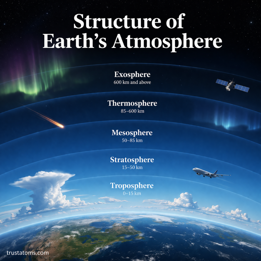
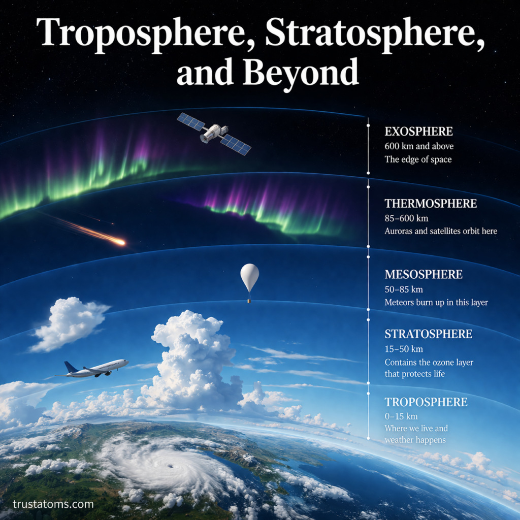
Earth’s atmosphere is not a single uniform layer—it is a structured system made up of distinct regions, each with its own properties and functions. From the air we breathe to the edge of space, these layers work together to support life, regulate climate, and protect the planet.

In this guide, we’ll explore the troposphere, stratosphere, and beyond, breaking down how each atmospheric layer behaves and why it matters.

Continue reading “Troposphere, Stratosphere, and Beyond”

Structure of Earth’s Atmosphere

Illustration showing the layers of Earth’s atmosphere including troposphere, stratosphere, mesosphere, thermosphere, and exosphere.
Layered diagram of Earth’s atmosphere showing its five main regions. trustatoms.com.

The Earth’s atmosphere is a layered envelope of gases that surrounds the planet, protects life, and regulates climate. It plays a crucial role in everything from breathing and weather patterns to shielding us from harmful radiation.

Understanding the structure of the atmosphere helps explain how weather forms, how planes fly, and why conditions change as you move higher above the surface.

Continue reading “Structure of Earth’s Atmosphere”

Landform Development in Active Regions

Illustration showing landform development in active regions with volcanoes, mountain ranges, trenches, and fault lines.
Illustration of landform development in active regions shaped by tectonic activity and volcanic processes. trustatoms.com

Earth’s most dramatic landscapes are found in geologically active regions—areas where tectonic plates interact, volcanoes erupt, and earthquakes reshape the land. These regions are constantly evolving, producing mountains, valleys, volcanoes, and other landforms at a much faster rate than stable areas.

Understanding landform development in active regions helps explain how Earth’s surface is built, reshaped, and transformed over time.

Continue reading “Landform Development in Active Regions”

Crustal Recycling Through Subduction

Illustration showing crustal recycling through subduction with oceanic plate sinking, magma formation, and volcanic activity.
Illustration of crustal recycling through subduction showing how oceanic crust is recycled into the mantle. trustatoms.com

Earth’s surface is not permanent. Oceanic crust is constantly created, destroyed, and recycled through a powerful geological process known as subduction. This process plays a key role in shaping continents, fueling volcanic activity, and maintaining the dynamic nature of our planet.

Crustal recycling through subduction is one of the most important mechanisms in plate tectonics, helping regulate Earth’s structure over millions of years.

Continue reading “Crustal Recycling Through Subduction”

Plate Boundaries and Resource Distribution

Illustration showing convergent, divergent, and transform plate boundaries with associated natural resource distribution like minerals and fossil fuels.
Illustration of plate boundaries and how they influence natural resource distribution on Earth. trustatoms.com

Earth’s surface is divided into massive moving pieces called tectonic plates. Where these plates meet—known as plate boundaries—intense geological activity occurs. These regions are not only responsible for earthquakes, volcanoes, and mountain building, but they also play a major role in the distribution of natural resources.

Understanding plate boundaries helps explain why valuable minerals, energy sources, and geological resources are concentrated in specific parts of the world.

Continue reading “Plate Boundaries and Resource Distribution”

Landscape Evolution Over Time

Illustration showing landscape evolution over time with mountains, rivers, volcanoes, and coastlines changing across different stages.
Illustration of landscape evolution over time showing how Earth’s surface changes through natural processes. trustatoms.com

Landscapes are constantly changing. Mountains rise and fall, rivers shift their paths, and coastlines advance or retreat. These changes occur over timescales ranging from sudden natural events to slow transformations that take millions of years.

Landscape evolution is the study of how Earth’s surface changes over time due to the interaction of geological, climatic, and biological processes.

Continue reading “Landscape Evolution Over Time”

Earth Surface Processes and Change

Illustration showing Earth surface processes including weathering, erosion, deposition, and tectonic activity shaping landscapes.
Illustration of Earth surface processes and change shaping mountains, rivers, and coastlines. trustatoms.com

Earth’s surface is constantly changing. Mountains rise, rivers carve valleys, coastlines shift, and landscapes evolve over time. These transformations are driven by a combination of internal forces from within the planet and external forces acting on the surface.

Understanding Earth surface processes helps explain how landforms develop, how natural hazards occur, and how our environment changes over time.

Continue reading “Earth Surface Processes and Change”

Mountain Uplift and Erosion Balance

Illustration showing mountain uplift and erosion balance with tectonic forces raising land and erosion processes wearing it down.
Illustration of mountain uplift and erosion balance shaping Earth’s landscapes. trustatoms.com

Mountains are not static features — they are constantly being built up and worn down. The balance between uplift (the process that raises land) and erosion (the process that wears it away) shapes the landscapes we see today.

Understanding this balance helps explain why some mountain ranges grow taller while others slowly disappear over millions of years.

Continue reading “Mountain Uplift and Erosion Balance”

Fault Lines and Seismic Activity

Illustration showing fault lines and seismic activity with earthquake origin, seismic waves, and ground rupture.
Fault lines and seismic activity illustrated with earthquake formation, seismic waves, and surface impact. trustatoms.com.

Earth’s surface is constantly shifting, even if those movements are too slow to notice. Beneath our feet, massive tectonic plates are in motion, and where they interact, stress builds up along fractures in the crust known as fault lines.

When that stress is suddenly released, it produces seismic activity—most commonly experienced as earthquakes.

Continue reading “Fault Lines and Seismic Activity”

Pangaea: Formation, Breakup, and Geological Evidence

Illustration showing Pangaea formation, breakup, and geological evidence including continental drift and fossil records.
Pangaea’s formation and breakup illustrated with supporting geological evidence like fossils and seafloor patterns. trustatoms.com.

Pangaea was a massive supercontinent that existed hundreds of millions of years ago, bringing together nearly all of Earth’s landmasses into one connected body. Its formation and eventual breakup played a major role in shaping today’s continents, oceans, and ecosystems.

Understanding Pangaea helps explain how Earth’s surface evolved—and why continents appear the way they do today.

Continue reading “Pangaea: Formation, Breakup, and Geological Evidence”