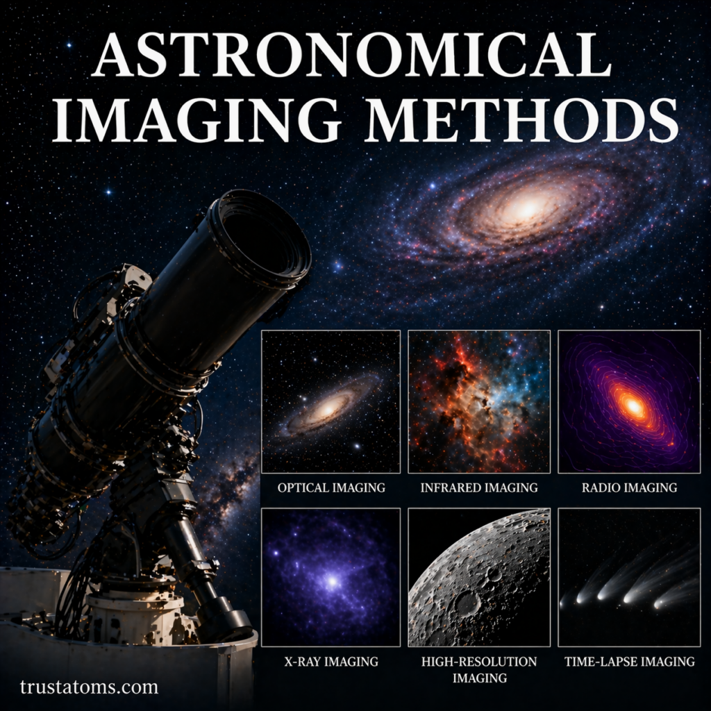
Volcanic Eruptions and Magma Movement: How Earth Releases Its Inner Heat

Illustration showing an erupting volcano with underground magma movement and lava flowing to the surface.
Illustration of volcanic eruptions and magma movement showing lava flow and underground magma pathways. trustatoms.com.

Volcanoes are among the most powerful natural features on Earth. From explosive eruptions to slow-moving lava flows, these events are driven by the movement of magma beneath the surface.

Understanding how magma forms, rises, and erupts helps explain why volcanoes behave so differently—and why some eruptions are far more dangerous than others.

Continue reading “Volcanic Eruptions and Magma Movement: How Earth Releases Its Inner Heat”

Aftershocks and Seismic Sequences: What Happens After an Earthquake?

Illustration showing an earthquake fault line with seismic waves representing foreshocks, mainshock, and aftershocks.
Illustration of aftershocks and seismic sequences showing fault movement and ongoing seismic activity after a major earthquake. trustatoms.com.

When a major earthquake strikes, the shaking doesn’t always end with the initial event. In many cases, the ground continues to tremble for days, weeks, or even months. These follow-up events—known as aftershocks—are part of a broader pattern called a seismic sequence.

Understanding aftershocks and seismic sequences helps scientists assess ongoing risks and gives communities a clearer picture of what to expect after a major quake.

Continue reading “Aftershocks and Seismic Sequences: What Happens After an Earthquake?”

Fault Lines and Earthquake Zones: Understanding Earth’s Shifting Crust

Illustration showing tectonic plates and a fault line causing earthquakes with surface damage and seismic activity.
Illustration of fault lines and earthquake zones showing tectonic plate movement and surface impact. trustatoms.com.

Earthquakes can seem sudden and unpredictable, but they’re usually the result of long-building stress along fault lines deep beneath the surface. Understanding where and why these movements occur helps scientists assess risk—and helps us better prepare for future seismic events.

In this guide, we’ll break down what fault lines are, how earthquake zones form, and where the most active regions on Earth are located.

Continue reading “Fault Lines and Earthquake Zones: Understanding Earth’s Shifting Crust”

Richter Scale and Seismic Intensity

Illustration comparing Richter Scale and seismic intensity showing measurement versus real-world earthquake effects.
Visual comparison of Richter Scale magnitude and seismic intensity impacts. trustatoms.com.

Earthquakes vary widely in strength and impact, from barely noticeable tremors to devastating events. To understand and compare these events, scientists use measurement systems that describe both the energy released and the effects felt on the ground.

Two key concepts are the Richter Scale and seismic intensity. While they are often confused, they measure very different aspects of an earthquake.

Continue reading “Richter Scale and Seismic Intensity”

Earthquakes: Causes and Measurement

Illustration of earthquakes showing tectonic plate movement, fault lines, epicenter, and seismograph recording seismic waves.
Educational illustration of earthquake causes and measurement, including tectonic plate movement, fault lines, and seismic wave recording. trustatoms.com

Earthquakes are among the most powerful natural events on Earth. They occur when energy stored within the planet’s crust is suddenly released, causing the ground to shake.

While some earthquakes are barely noticeable, others can cause widespread destruction. Understanding what causes earthquakes and how they are measured is essential for improving safety, predicting risks, and studying Earth’s internal structure.

Continue reading “Earthquakes: Causes and Measurement”

Global Climate Monitoring Systems

Global climate monitoring systems illustration showing satellites, weather stations, ocean buoys, and Earth observation technology.
Illustration of global climate monitoring systems featuring satellites, ocean sensors, and ground-based stations tracking Earth’s climate. trustatoms.com

Global climate monitoring systems are essential tools for understanding how Earth’s climate is changing over time. These systems collect, analyze, and interpret data from across the planet—helping scientists track temperature trends, atmospheric changes, ocean conditions, and more.

As climate change becomes a growing global concern, accurate and continuous monitoring is critical for informed decision-making, environmental protection, and long-term planning.

Continue reading “Global Climate Monitoring Systems”

Desertification and Regional Climate Shifts

Illustration of desertification and regional climate shifts showing dry cracked land transitioning into a green landscape with rainfall.
Visual representation of desertification and climate shifts, contrasting arid land with fertile terrain influenced by changing weather patterns. trustatoms.com

Desertification is one of the most significant environmental challenges affecting dryland regions around the world. It involves the gradual degradation of fertile land into arid, unproductive landscapes.

While often associated with expanding deserts, desertification is not simply the spread of sand dunes. It is a complex process driven by climate variability, human activity, and ecological imbalance.

Understanding how desertification interacts with regional climate shifts is essential for managing land resources, protecting ecosystems, and sustaining human livelihoods.

Continue reading “Desertification and Regional Climate Shifts”

Monsoon Systems and Climate Interaction

Monsoon systems and climate interaction illustration showing ocean winds, heavy rainfall, and land heating effects.
Illustration of monsoon systems showing seasonal wind patterns, ocean moisture flow, and heavy rainfall over land. trustatoms.com

Monsoon systems are among the most powerful and influential climate patterns on Earth. They shape weather, ecosystems, agriculture, and even economies across large regions of the planet.

While often associated with heavy seasonal rains, monsoons are far more complex. They are driven by interactions between land, ocean, and atmospheric circulation—making them a key part of the global climate system.

Understanding how monsoons work and how they interact with climate variability is essential for predicting weather patterns, managing water resources, and preparing for extreme events.

Continue reading “Monsoon Systems and Climate Interaction”

Long-Term Climate Variability

Illustration showing long-term climate variability with transitions between ice age conditions and warmer environments over time.
Long-term climate variability shapes Earth’s environment through cycles of cooling and warming. trustatoms.com.

Earth’s climate is not static—it changes over time due to a combination of natural processes and external influences. Long-term climate variability refers to climate changes that occur over decades, centuries, or even millions of years.

These variations shape ice ages, warm periods, and shifts in ecosystems. Understanding them helps scientists distinguish between natural climate patterns and modern, human-driven changes.

Continue reading “Long-Term Climate Variability”

Anthropogenic Influences in Climate Systems

Illustration showing human impact on climate with industrial pollution on one side and renewable energy solutions on the other.
Human activities influence climate systems through emissions, land use, and energy choices. trustatoms.com.

Anthropogenic influences refer to the impact of human activities on Earth’s natural systems. In the context of climate, these influences have become the dominant driver of recent global changes, affecting temperature, weather patterns, oceans, and ecosystems.

Understanding how human actions alter climate systems is essential for addressing environmental challenges and planning for the future.

Continue reading “Anthropogenic Influences in Climate Systems”