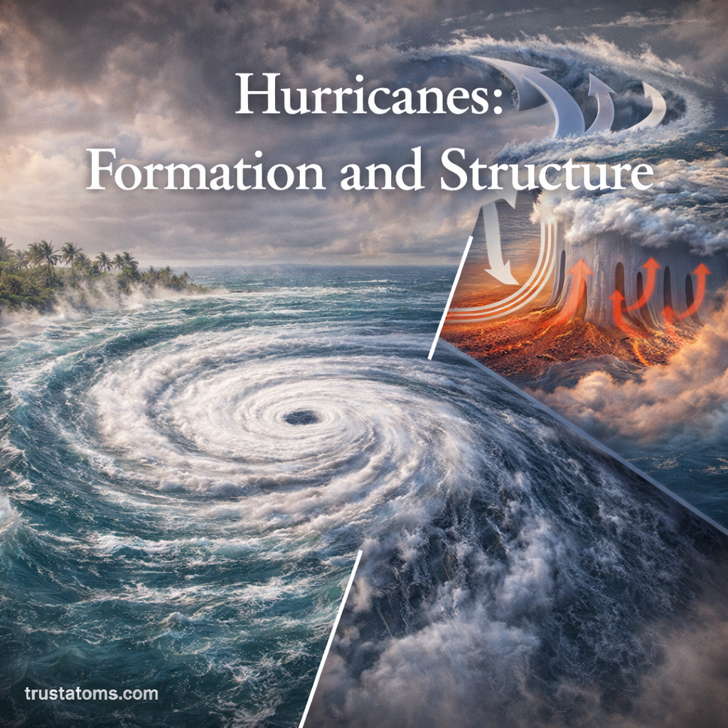
Mountain Uplift and Erosion Balance

Illustration showing mountain uplift and erosion balance with tectonic forces raising land and erosion processes wearing it down.
Illustration of mountain uplift and erosion balance shaping Earth’s landscapes. trustatoms.com

Mountains are not static features — they are constantly being built up and worn down. The balance between uplift (the process that raises land) and erosion (the process that wears it away) shapes the landscapes we see today.

Understanding this balance helps explain why some mountain ranges grow taller while others slowly disappear over millions of years.

Continue reading “Mountain Uplift and Erosion Balance”

Fault Lines and Seismic Activity

Illustration showing fault lines and seismic activity with earthquake origin, seismic waves, and ground rupture.
Fault lines and seismic activity illustrated with earthquake formation, seismic waves, and surface impact. trustatoms.com.

Earth’s surface is constantly shifting, even if those movements are too slow to notice. Beneath our feet, massive tectonic plates are in motion, and where they interact, stress builds up along fractures in the crust known as fault lines.

When that stress is suddenly released, it produces seismic activity—most commonly experienced as earthquakes.

Continue reading “Fault Lines and Seismic Activity”

Pangaea: Formation, Breakup, and Geological Evidence

Illustration showing Pangaea formation, breakup, and geological evidence including continental drift and fossil records.
Pangaea’s formation and breakup illustrated with supporting geological evidence like fossils and seafloor patterns. trustatoms.com.

Pangaea was a massive supercontinent that existed hundreds of millions of years ago, bringing together nearly all of Earth’s landmasses into one connected body. Its formation and eventual breakup played a major role in shaping today’s continents, oceans, and ecosystems.

Understanding Pangaea helps explain how Earth’s surface evolved—and why continents appear the way they do today.

Continue reading “Pangaea: Formation, Breakup, and Geological Evidence”

Supercontinents and Continental Cycles

Illustration showing supercontinents and continental cycles with stages from Pangaea formation to modern continents.
Supercontinent cycle showing the formation, breakup, and reconfiguration of continents over time. trustatoms.com.

Earth’s continents may seem fixed, but over geologic time they are constantly moving, colliding, and separating. This long-term process is known as the continental cycle (or supercontinent cycle), and it has shaped the planet’s surface for billions of years.

At certain points in this cycle, most of Earth’s landmass joins together to form a supercontinent—a single massive landmass that dramatically influences climate, oceans, and life.

Continue reading “Supercontinents and Continental Cycles”

Plate Reconstruction in Geological History

Illustration showing plate reconstruction in geological history with continental drift from Pangaea to present day.
Plate reconstruction showing the movement of continents from Pangaea to present day. trustatoms.com.

Plate reconstruction is a scientific method used to piece together the past positions and movements of Earth’s tectonic plates. By analyzing geological, paleontological, and geophysical evidence, scientists can “rewind” the planet’s history and understand how continents and oceans have shifted over millions—even billions—of years.

This process helps explain the formation of mountains, oceans, earthquakes, and even patterns of life on Earth.

Continue reading “Plate Reconstruction in Geological History”

Tsunami Formation and Seafloor Movement

Illustration showing tsunami formation caused by seafloor movement with tectonic plate displacement and ocean wave buildup.
Tsunami formation illustrated through seafloor movement and tectonic plate displacement. trustatoms.com.

Tsunamis are among the most powerful and destructive natural events on Earth. Unlike regular ocean waves caused by wind, tsunamis are triggered by sudden movements of the seafloor, displacing massive amounts of water in a short time.

Understanding how tsunamis form—and how seafloor movement drives them—helps explain why these waves can travel across entire oceans and cause devastating coastal impacts.

Continue reading “Tsunami Formation and Seafloor Movement”

Volcanic Eruption Patterns

Illustration showing different volcanic eruption types including effusive, Strombolian, Vulcanian, and Plinian eruptions.
Illustration of volcanic eruption patterns, showing different eruption styles based on magma composition and gas pressure. trustatoms.com

Volcanoes are among the most powerful and dynamic features on Earth. While eruptions may appear unpredictable, scientists have identified clear patterns in how volcanoes behave. These eruption patterns depend on factors such as magma composition, gas content, and tectonic setting.

Understanding volcanic eruption patterns helps scientists forecast activity, reduce risks, and better understand Earth’s internal processes.

Continue reading “Volcanic Eruption Patterns”

Earthquake Zones and Plate Interaction

Illustration of global earthquake zones along tectonic plate boundaries showing plate movement and seismic activity.
Illustration showing earthquake zones along tectonic plate boundaries and how plate interactions cause seismic activity. trustatoms.com

Earthquakes are one of the most powerful natural forces on our planet. While they may seem sudden and unpredictable, most earthquakes occur in specific regions known as earthquake zones—areas closely linked to the movement and interaction of tectonic plates.

Understanding how plate interactions create earthquake zones helps explain where earthquakes are most likely to occur and why they happen in the first place.

Continue reading “Earthquake Zones and Plate Interaction”

Plate Motion Measurement Using GPS

Illustration of GPS station measuring tectonic plate motion with satellite signals and ground movement arrows.
Illustration showing how GPS technology measures tectonic plate motion using satellites and ground-based stations. trustatoms.com

The Earth’s surface is constantly in motion, even though we don’t feel it. Massive sections of the crust, known as tectonic plates, move slowly over time—sometimes only a few centimeters per year.

Today, scientists can measure this movement with incredible precision using Global Positioning System (GPS) technology. This has revolutionized our understanding of plate tectonics, earthquakes, and Earth’s dynamic behavior.

Continue reading “Plate Motion Measurement Using GPS”

Delta Formation and Sediment Deposition

River delta illustration showing distributary channels, sediment deposition, and land formation at a river mouth.
Illustration of delta formation as rivers deposit sediment and create branching distributary channels. trustatoms.com

River deltas are some of the most fertile and dynamic landforms on Earth. Found where rivers meet larger bodies of water such as oceans, seas, or lakes, deltas are created through the gradual process of sediment deposition.

These landscapes are constantly changing, shaped by the balance between river flow, sediment supply, and wave or tidal activity. Understanding how deltas form helps explain not only Earth’s surface processes but also the development of ecosystems and human settlements.

Continue reading “Delta Formation and Sediment Deposition”