Trust Atoms publishes educational content designed to make science and complex topics easier to understand. Our articles focus on clear explanations, curiosity-driven learning, and accessible information across subjects including astronomy, biology, chemistry, physics, human anatomy, and more.
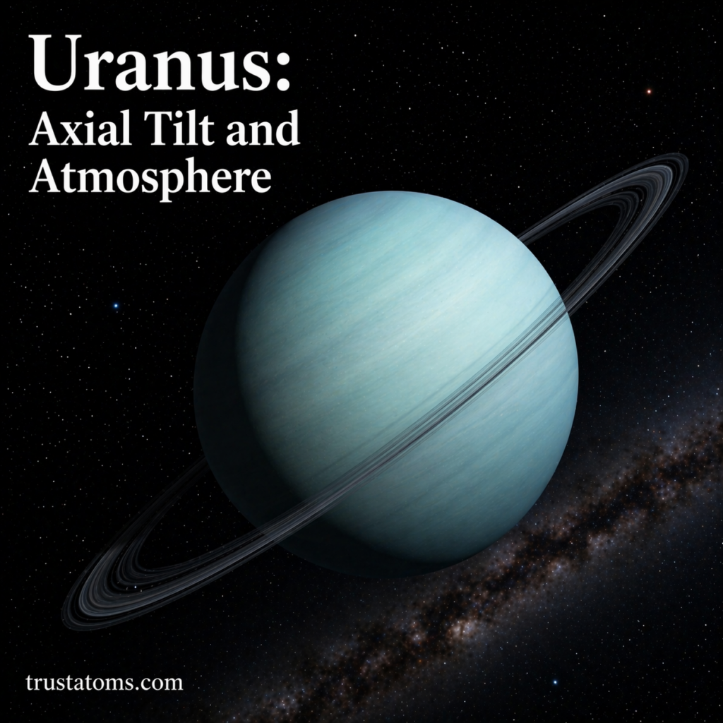
Illustration of Uranus highlighting its extreme axial tilt and atmospheric appearance. trustatoms.com.
Uranus is one of the most unusual planets in the Solar System. Known for its striking blue-green color and extreme axial tilt, Uranus challenges many of the patterns seen in other planets.
This article explores two of its most fascinating features: its sideways rotation and its unique atmospheric composition.
Illustration of Saturn highlighting its iconic ring system and nearby moons. trustatoms.com.
Saturn is one of the most visually striking planets in the Solar System, best known for its magnificent ring system. As a gas giant, Saturn is composed mostly of hydrogen and helium, but its rings and moons make it one of the most fascinating objects to study in astronomy.
This guide explores Saturn’s structure, its iconic rings, and why this planet continues to captivate scientists and observers alike.
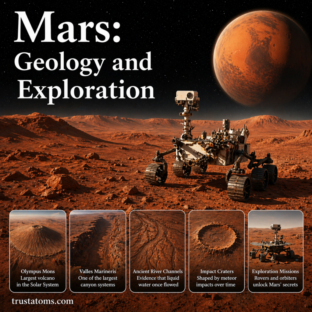
Illustration of Mars featuring a rover and major geological landmarks related to exploration. trustatoms.com.
Mars—often called the Red Planet—is one of the most studied worlds in our Solar System. Its dusty surface, massive volcanoes, and evidence of ancient water make it a key focus in the search for past or present life beyond Earth.
In this guide, we’ll explore Mars’ geology and the missions that have helped scientists uncover its secrets.
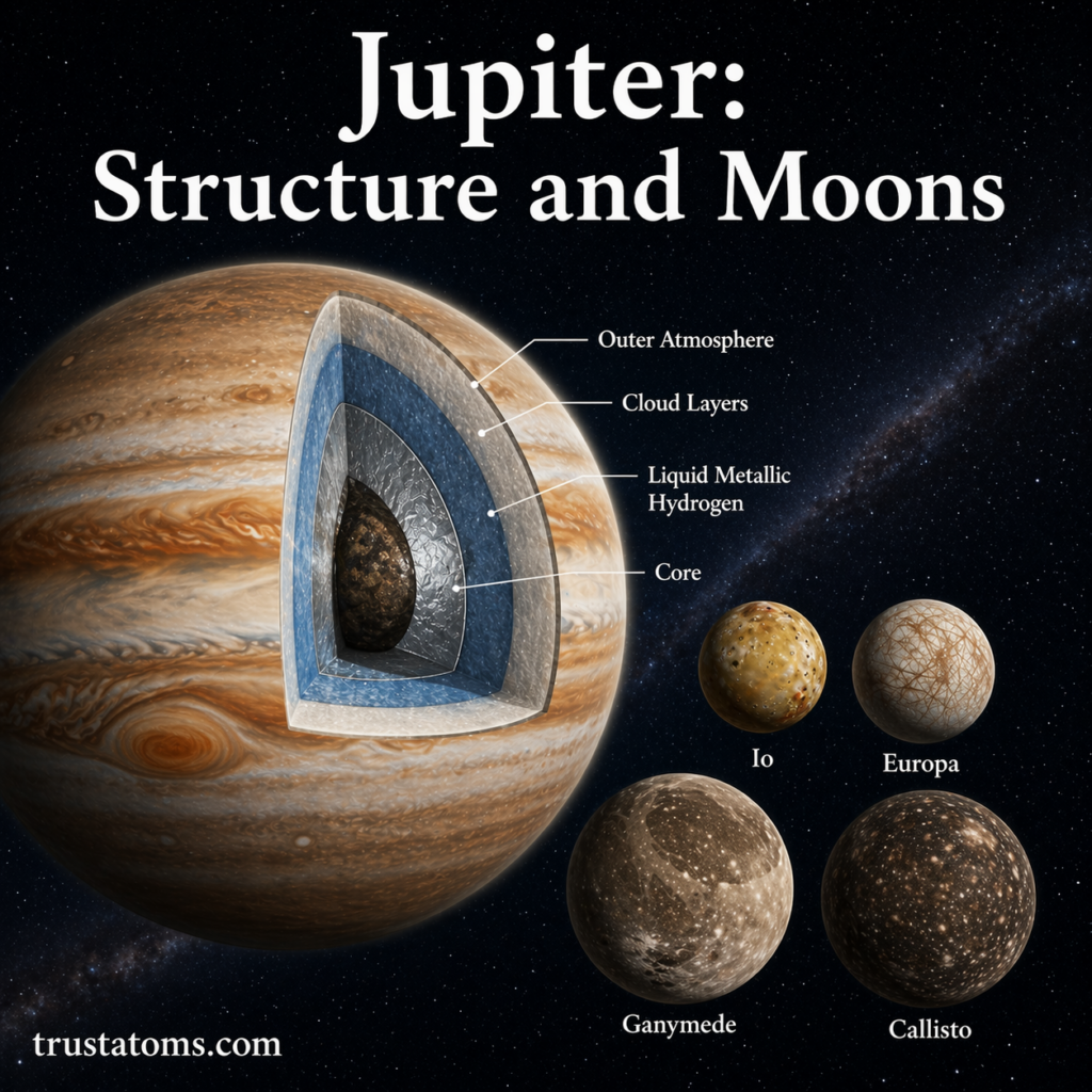
Illustration of Jupiter’s internal structure and its major moons in the Solar System. trustatoms.com.
Jupiter is the largest planet in our Solar System and a fascinating world of swirling storms, powerful gravity, and dozens of moons. Known as a gas giant, Jupiter plays a major role in shaping the Solar System’s structure and protecting inner planets like Earth from cosmic debris.
This guide explores Jupiter’s internal structure and its diverse system of moons, offering a clear understanding of why this planet is so unique.
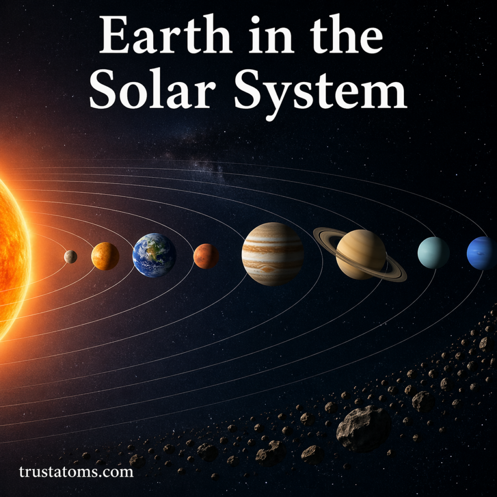
Simple illustration of Earth’s position within the Solar System. trustatoms.com.
Earth is our home planet and the only known place in the universe where life exists. Positioned within the vast structure of the Solar System, Earth occupies a unique and favorable location that allows life to thrive.
Understanding Earth’s place in the Solar System helps explain everything from our climate and seasons to the conditions that make life possible.
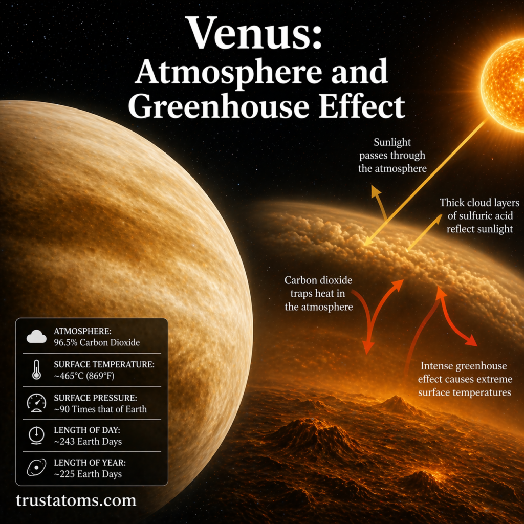
A visual depiction of Venus’s dense atmosphere and powerful greenhouse effect trapping heat and creating extreme surface temperatures. trustatoms.com
Venus is often called Earth’s “sister planet” because of its similar size and composition—but that’s where the similarities end. Beneath its thick clouds lies one of the most extreme environments in the Solar System, driven by a powerful greenhouse effect.
Understanding Venus helps scientists study climate systems, atmospheric science, and even the future of planetary environments.
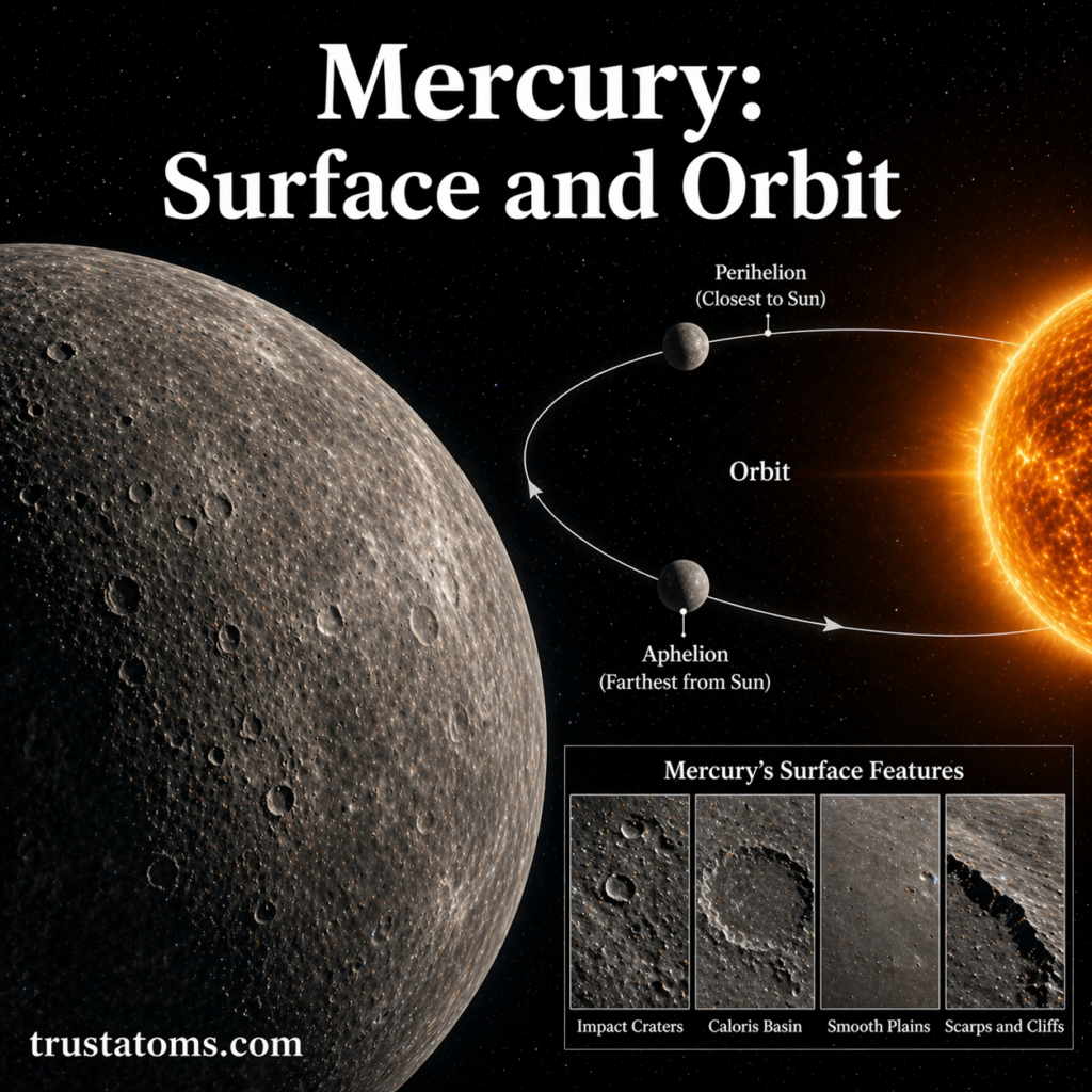
A visual depiction of Mercury’s rocky surface and its fast, elliptical orbit around the Sun. trustatoms.com
Mercury is the closest planet to the Sun and one of the most extreme worlds in the Solar System. With scorching daytime temperatures, freezing nights, and a heavily cratered surface, Mercury offers a fascinating look into planetary formation and survival under intense solar conditions.
In this guide, we’ll explore Mercury’s surface features and its unique orbital behavior.
Overview of Mercury
Mercury is the smallest of the eight planets and has no moons or rings.
Key Facts About Mercury
Distance from the Sun: ~58 million km (36 million miles)
Diameter: ~4,880 km
Length of a day (rotation): ~59 Earth days
Length of a year (orbit): ~88 Earth days
Surface temperature: −180°C to 430°C
Despite being closest to the Sun, Mercury is not the hottest planet—that title belongs to Venus due to its thick atmosphere.
Mercury’s Surface: A Harsh Landscape
Mercury’s surface is rocky, barren, and heavily cratered, similar in appearance to Earth’s Moon.
Impact Craters
One of the most defining features of Mercury is its abundance of impact craters.
Formed by collisions with asteroids and comets
Range from small pits to massive basins
Indicate an ancient and relatively unchanged surface
Because Mercury has almost no atmosphere, incoming objects are not burned up before impact.
Caloris Basin
The Caloris Basin is one of the largest impact structures in the Solar System.
Diameter: ~1,550 km
Created by a massive collision billions of years ago
Surrounded by rings of mountains
On the opposite side of the planet, strange terrain formed due to shockwaves from the impact.
Smooth Plains
Mercury also contains regions of smooth plains, which are flatter and less cratered.
Likely formed by ancient volcanic activity
Lava flows filled in older craters
Similar to lunar maria (dark plains on the Moon)
These areas suggest Mercury was once geologically active.
Scarps and Cliffs
Mercury’s surface is marked by long, steep cliffs called lobate scarps.
Formed as the planet cooled and shrank
Can stretch for hundreds of kilometers
Evidence of tectonic activity
These features show that Mercury’s interior has changed over time.
Temperature Extremes
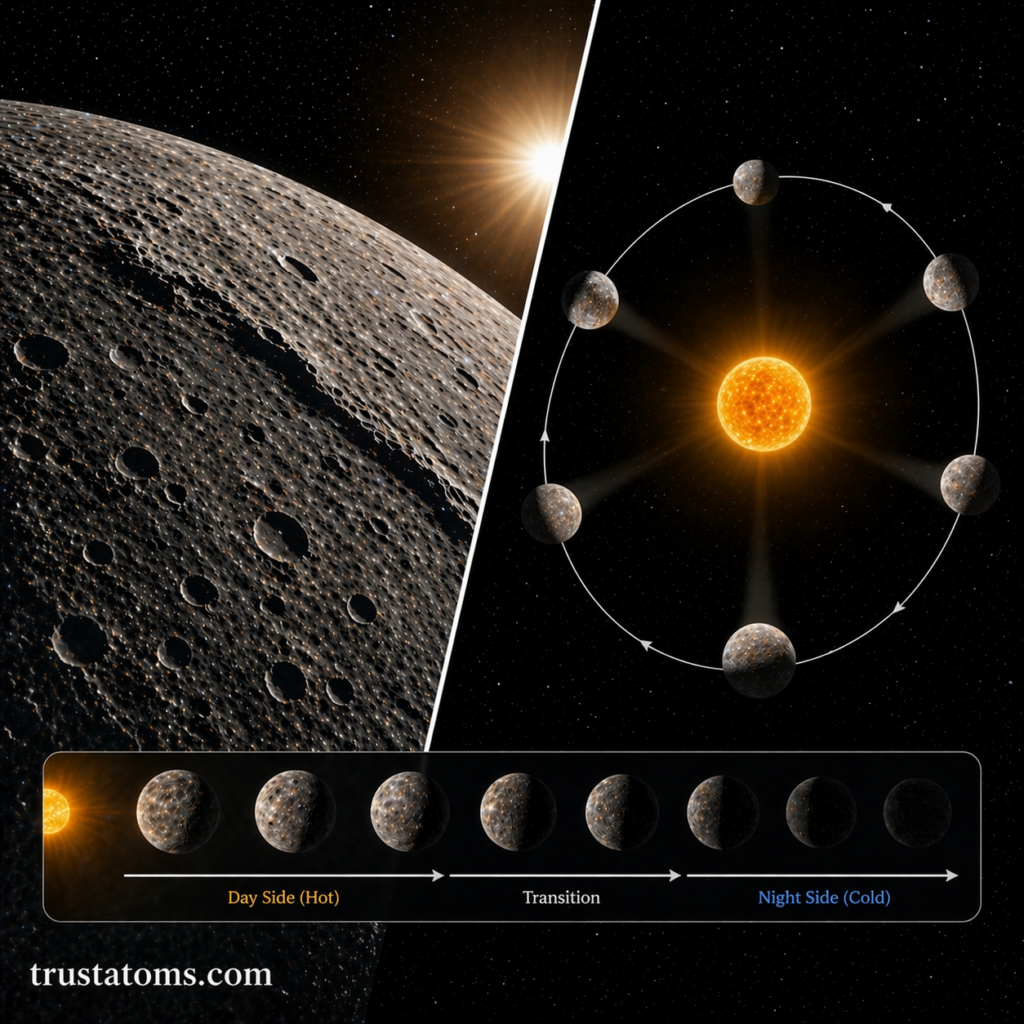
A split-view diagram illustrating Mercury’s surface features, orbital motion, and extreme transition from intense daytime heat to freezing nighttime conditions. trustatoms.com
Mercury experiences the most extreme temperature variations of any planet.
Why Temperatures Vary So Much
No significant atmosphere to trap heat
Slow rotation
Direct exposure to the Sun
Temperature Range
Daytime: Up to 430°C (800°F)
Nighttime: Down to −180°C (−290°F)
This dramatic contrast makes Mercury an extreme environment.
Mercury’s Orbit: Fast and Unusual
Mercury has one of the most unique orbits in the Solar System.
Short Year, Long Day
Mercury completes an orbit in just 88 Earth days
It rotates slowly, taking 59 Earth days for one full spin
This leads to an unusual relationship between its day and year.
3:2 Spin-Orbit Resonance
Mercury is locked in a 3:2 spin-orbit resonance.
What This Means
Mercury rotates 3 times for every 2 orbits around the Sun
A single solar day (sunrise to sunrise) lasts 176 Earth days
This creates long periods of daylight and darkness.
Highly Elliptical Orbit
Mercury’s orbit is not a perfect circle—it is elliptical.
Distance from the Sun varies significantly
Closest point: perihelion
Farthest point: aphelion
This variation affects how much solar energy Mercury receives.
Why Mercury Has No Atmosphere
Mercury has only a very thin exosphere instead of a true atmosphere.
Reasons for This
Weak gravity cannot hold gases
Intense solar radiation strips particles away
High temperatures prevent gas retention
Without an atmosphere, Mercury is exposed directly to space conditions.
Exploration of Mercury
Mercury has been explored by a few spacecraft missions.
Notable Missions
Mariner 10 (NASA): First flyby mission in the 1970s
MESSENGER (NASA): Orbited Mercury from 2011 to 2015
These missions have provided detailed maps and data about the planet.
Why Mercury Matters
Studying Mercury helps scientists understand:
Planetary formation near stars
Effects of extreme solar radiation
Geological evolution of rocky planets
Conditions on exoplanets close to their stars
Mercury serves as a natural laboratory for extreme planetary science.
Final Thoughts
Mercury may be small, but it is one of the most intriguing planets in the Solar System. Its cratered surface, dramatic temperature swings, and unusual orbit make it a unique world worth studying.
By exploring Mercury, scientists gain valuable insights into how planets behave under intense conditions—helping us better understand both our Solar System and distant planetary systems.
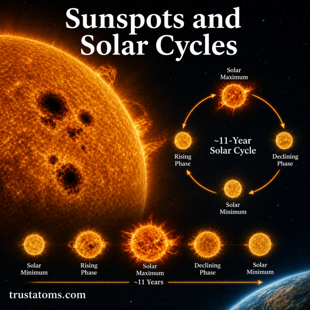
A visual representation of sunspots on the Sun and the repeating 11-year solar cycle from minimum to maximum activity. trustatoms.com
The Sun may look like a steady, glowing sphere, but it is constantly changing. One of the most visible signs of solar activity is the appearance of sunspots—dark patches on the Sun’s surface that reveal powerful magnetic forces at work.
These sunspots are closely tied to the solar cycle, a repeating pattern of activity that affects everything from space weather to satellite communications on Earth.
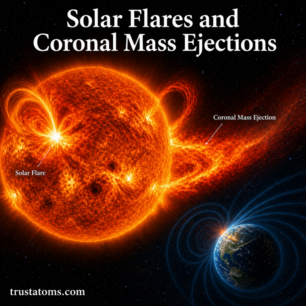
A visual representation of solar flares and coronal mass ejections erupting from the Sun and interacting with Earth’s magnetic field. trustatoms.com
The Sun is not a calm, unchanging star—it is highly active and capable of releasing enormous bursts of energy. Two of the most powerful solar events are solar flares and coronal mass ejections (CMEs).
These phenomena can affect space near Earth, disrupt technology, and even influence our planet’s magnetic environment. Understanding them is essential for both astronomy and modern infrastructure.
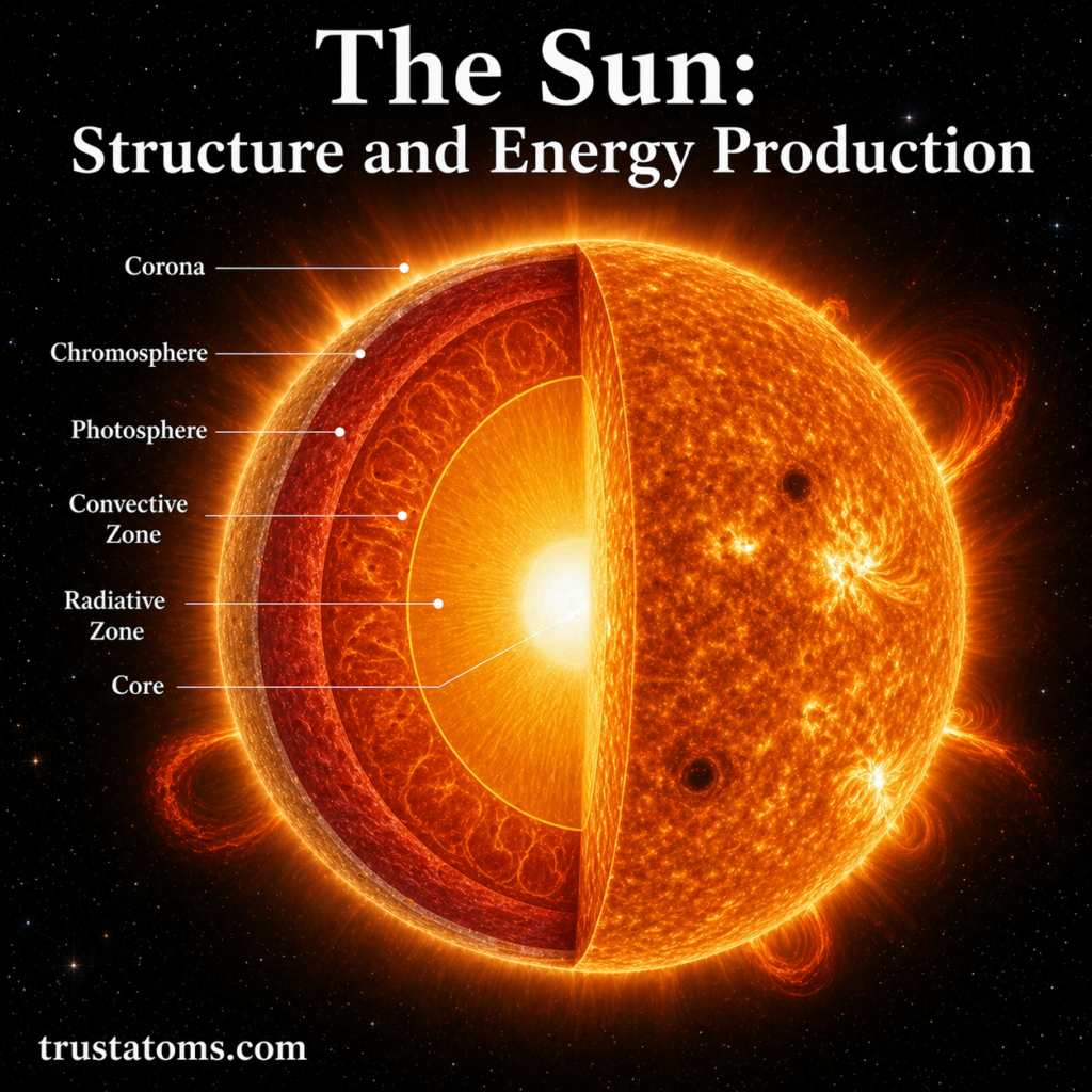
A detailed cross-sectional view of the Sun highlighting its internal layers and how energy moves from the core to the outer atmosphere. trustatoms.com
The Sun is the heart of our Solar System and the primary source of energy for life on Earth. While it appears as a simple glowing sphere in the sky, the Sun is a complex, dynamic star with multiple layers and powerful energy-generating processes happening deep within its core.
Understanding the Sun’s structure and how it produces energy helps explain everything from sunlight and seasons to solar flares and space weather.