Coastal Landforms and Wave Action

Coastal landscape illustration showing sea cliffs, sea arch, sea stack, beach, and wave action shaping the shoreline.
Illustration of coastal landforms shaped by wave action, including cliffs, arches, stacks, and beaches. trustatoms.com

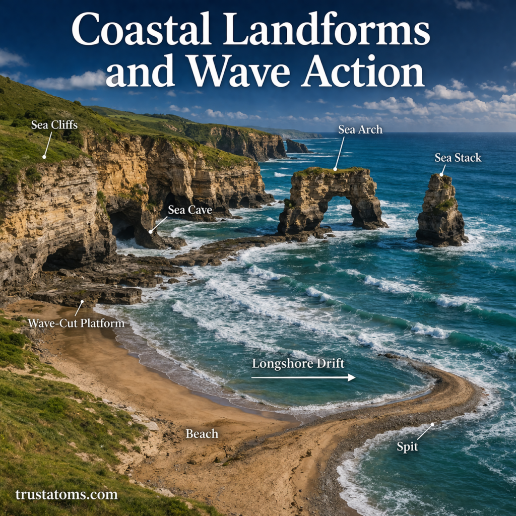
Coastal landforms are constantly shaped and reshaped by the powerful forces of waves, tides, and currents. Along shorelines around the world, wave action plays a central role in carving cliffs, forming beaches, and creating dramatic features like arches and sea stacks.

Understanding how waves interact with land helps explain why coastlines look the way they do—and why they are always changing.

Continue reading “Coastal Landforms and Wave Action”

Karst Landscapes and Limestone Erosion

Karst landscape illustration showing sinkholes, limestone caves, underground river, and erosion processes.
Illustration of karst landscapes formed by limestone erosion, featuring caves, sinkholes, and underground water systems. trustatoms.com

Karst landscapes are some of the most fascinating and unique landforms on Earth. Characterized by caves, sinkholes, disappearing rivers, and underground drainage systems, these environments are shaped primarily by the slow but powerful process of limestone erosion.

Understanding how karst landscapes form not only reveals the hidden dynamics of Earth’s surface but also highlights the importance of water in shaping the natural world.

Continue reading “Karst Landscapes and Limestone Erosion”

Desert Landforms and Wind Erosion

Illustration of desert landforms including sand dunes, yardangs, desert pavement, and ventifacts shaped by wind erosion.
A detailed desert landscape showing how wind erosion shapes dunes, rocks, and surface features over time. trustatoms.com

Deserts are often seen as barren and lifeless, but they are some of the most dynamic landscapes on Earth. Shaped primarily by wind and limited water, deserts feature unique landforms created through erosion, transportation, and deposition.

Understanding desert landforms and wind erosion reveals how even the harshest environments are constantly changing over time.

Continue reading “Desert Landforms and Wind Erosion”

River Systems and Valley Formation

Illustration of a river system showing source, tributaries, meanders, floodplains, and delta formation across a landscape.
A detailed river system diagram showing how flowing water shapes valleys, meanders, floodplains, and deltas. trustatoms.com

Rivers are among the most powerful natural forces shaping Earth’s surface. Over time, flowing water cuts through rock and soil, creating valleys, transporting sediments, and forming complex landscapes.

Understanding river systems and valley formation helps explain how landscapes evolve, how ecosystems develop, and how water moves across the planet.

Continue reading “River Systems and Valley Formation”

Glacial Landforms and Ice Movement

Illustration of glacial landforms including U-shaped valley, moraines, drumlins, and ice movement through a mountain landscape.
A detailed glacier landscape showing how ice movement shapes landforms like valleys, moraines, and drumlins. trustatoms.com

Glaciers are powerful natural forces that shape Earth’s surface over thousands to millions of years. These massive, slow-moving bodies of ice carve valleys, transport rock, and create unique landforms that tell the story of past climates.

Understanding glacial landforms and ice movement helps explain how landscapes evolve and how ice has influenced regions across the world.

Continue reading “Glacial Landforms and Ice Movement”

Folding and Faulting in Earth’s Crust

Illustration showing folded rock layers and fault lines demonstrating folding and faulting processes in Earth’s crust.
A geological cross-section illustrating how folding bends rock layers and faulting breaks and shifts the crust. trustatoms.com

Earth’s crust is constantly under stress from tectonic forces. Over time, these forces cause rocks to bend, break, and shift—processes known as folding and faulting.

These geological processes are responsible for shaping mountains, valleys, and many of the landscapes we see today. They also play a major role in earthquakes and the overall structure of Earth’s surface.

Continue reading “Folding and Faulting in Earth’s Crust”

Continental Collision Processes

Illustration of continental collision showing two tectonic plates converging and forming mountains through crustal thickening.
A cross-section diagram showing how continental plates collide and form mountain ranges through compression and uplift. trustatoms.com

Continental collision is one of the most powerful geological processes on Earth. It occurs when two continental tectonic plates move toward each other and collide, reshaping the planet’s surface on a massive scale.

Unlike oceanic plates, continental plates are thick and buoyant. When they collide, neither plate easily sinks into the mantle. Instead, the crust crumples, folds, and rises—creating some of the world’s largest mountain ranges.

Continue reading “Continental Collision Processes”

Earth’s Major Tectonic Plates

Illustration of Earth’s major tectonic plates labeled on a global map showing plate boundaries and continents.
A simplified global diagram showing Earth’s major tectonic plates and their boundaries. trustatoms.com

Earth’s surface may look solid and unchanging, but it is actually broken into massive pieces called tectonic plates. These plates are constantly moving—albeit very slowly—shaping the continents, oceans, mountains, and even influencing earthquakes and volcanic activity.

Understanding Earth’s major tectonic plates helps explain why natural disasters occur, how continents drift over time, and how our planet continues to evolve.

Continue reading “Earth’s Major Tectonic Plates”

Hotspots and Mantle Plumes

Illustration showing mantle plume rising beneath a tectonic plate forming a hotspot and volcanic island chain.
Illustration of hotspots and mantle plumes creating volcanic island chains as tectonic plates move. trustatoms.com.

Hotspots and mantle plumes are powerful geological phenomena that help explain volcanic activity far from tectonic plate boundaries. Unlike most volcanoes, which form along plate edges, hotspots can occur in the middle of plates—creating chains of volcanoes and islands across the ocean floor.

From the Hawaiian Islands to Yellowstone, these features reveal deep connections between Earth’s surface and its interior.

Continue reading “Hotspots and Mantle Plumes”

Ocean Trenches and Deep-Sea Topography

Illustration of ocean trenches and deep-sea topography showing abyssal plains, seamounts, and mid-ocean ridges beneath the ocean surface.
Illustration of ocean trenches and deep-sea features including ridges, plains, and seamounts. trustatoms.com.

The deep ocean is one of the least explored regions on Earth, yet it contains some of the planet’s most dramatic landscapes. Among these features, ocean trenches stand out as the deepest and most extreme environments, plunging miles below the ocean surface.

Understanding ocean trenches and deep-sea topography helps scientists uncover how Earth’s crust behaves, how plate tectonics operates beneath the oceans, and how life survives in extreme conditions.

Continue reading “Ocean Trenches and Deep-Sea Topography”