Sedimentary basins and stratigraphy are essential concepts in Earth science that help explain how layers of rock form, accumulate, and record Earth’s history over millions of years. Together, they provide a framework for understanding geological processes, natural resources, and past environments.
What Is a Sedimentary Basin?
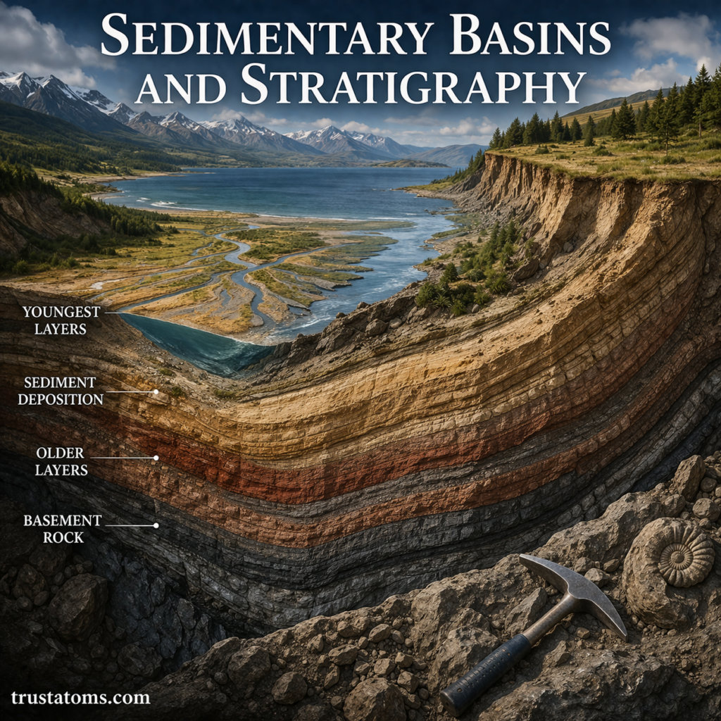
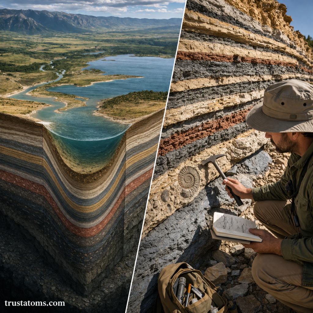
A sedimentary basin is a low-lying area of Earth’s crust where sediments accumulate over time.
These basins form when the crust subsides (sinks), creating space for sediments such as sand, mud, and organic material to build up in layers.
Key Characteristics of Sedimentary Basins
- Long-term accumulation of sediments
- Gradual subsidence of the crust
- Formation of layered sedimentary rocks
- Preservation of fossils and environmental records
Sedimentary basins are found on continents and beneath oceans.
How Sedimentary Basins Form
Sedimentary basins develop through tectonic and geological processes that create space for sediment to accumulate.
Major Formation Mechanisms
1. Tectonic Extension
- The crust is stretched and thinned
- Blocks of crust drop down, forming basins
- Common in rift zones
2. Compression and Folding
- Plates collide and compress the crust
- Downwarping creates basins near mountain ranges
3. Thermal Subsidence
- After tectonic activity, the crust cools and sinks
- Creates long-lasting, stable basins
4. Flexural Loading
- Heavy loads (like mountains or glaciers) bend the crust downward
- Basins form adjacent to these loads
Types of Sedimentary Basins
Different tectonic settings produce different types of basins.
Common Basin Types
- Rift basins – Formed by crustal stretching
- Foreland basins – Formed next to mountain belts
- Passive margin basins – Found along stable continental edges
- Intracratonic basins – Located within stable interior regions
Each type reflects the tectonic forces acting on the crust.
What Is Stratigraphy?
Stratigraphy is the study of rock layers (strata) and their relationships.
It focuses on:
- The order of rock layers
- Their composition and characteristics
- The timing of geological events
Stratigraphy allows scientists to reconstruct Earth’s history by analyzing layered rocks.
Principles of Stratigraphy
Stratigraphy is based on several key principles that help interpret rock layers.
1. Law of Superposition
- In undisturbed layers, the oldest rocks are at the bottom
- Younger layers are deposited on top
2. Original Horizontality
- Sediments are originally deposited in horizontal layers
- Tilting or folding occurs after deposition
3. Lateral Continuity
- Layers extend outward until they thin or encounter barriers
- Separated layers were once connected
4. Cross-Cutting Relationships
- A feature that cuts through rocks is younger than the rocks it cuts
5. Fossil Succession
- Fossils appear in a predictable order through time
- This helps date and correlate rock layers
How Sedimentary Basins and Stratigraphy Work Together
Sedimentary basins provide the space for layers to accumulate, while stratigraphy helps interpret those layers.
Together, they allow scientists to:
- Reconstruct past environments (rivers, deserts, oceans)
- Understand changes in sea level
- Identify periods of tectonic activity
- Track climate changes over time
Stratigraphy gives meaning to the layers formed within basins.
Stratigraphic Layers and Depositional Environments
Each layer within a basin represents a specific environment at the time of deposition.
Common Depositional Environments
- Fluvial (river) – Sand and gravel deposits
- Marine (ocean) – Fine sediments like mud and limestone
- Desert – Wind-blown sand forming dunes
- Delta – Mixed sediments from rivers entering oceans
By studying these layers, scientists can determine how environments shifted over time.
Importance in Natural Resources
Sedimentary basins are critical for natural resource exploration.
Key Resources Found in Basins
- Oil and natural gas
- Coal deposits
- Groundwater reservoirs
- Minerals and building materials
Stratigraphy helps locate these resources by identifying specific rock layers where they are likely to occur.
Modern Tools in Stratigraphy
Scientists use advanced methods to study basins and rock layers:
- Seismic imaging to map underground structures
- Radiometric dating to determine ages
- Core sampling to analyze rock sequences
- Satellite data to study large-scale formations
These tools provide more accurate and detailed geological interpretations.
Challenges in Interpreting Stratigraphy
Despite its usefulness, stratigraphy can be complex.
Common Challenges
- Erosion removing parts of the rock record
- Folding and faulting disrupting layers
- Gaps in deposition (unconformities)
- Similar-looking layers in different locations
Careful analysis is required to correctly interpret geological history.
Why Sedimentary Basins and Stratigraphy Matter
Understanding sedimentary basins and stratigraphy is essential for:
- Reconstructing Earth’s geological history
- Predicting natural resources
- Studying environmental and climate changes
- Assessing geological hazards
These concepts provide a timeline of Earth’s past and a guide to its future.
Final Thoughts
Sedimentary basins and stratigraphy together form the backbone of geological interpretation. Basins act as natural record keepers, while stratigraphy helps decode the layers within them.
By studying these layered records, scientists can uncover the story of Earth—how landscapes formed, how environments changed, and how life evolved over time.