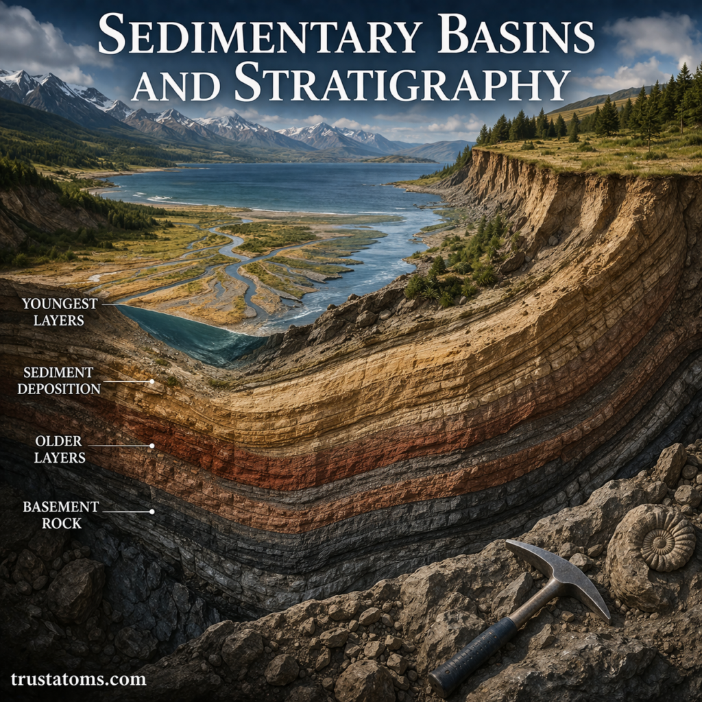
Sedimentary basins are regions where sediment accumulates over time, often as Earth’s crust gradually sinks and creates space for new deposits. Stratigraphy is the study of rock layers and their relationships, allowing geologists to reconstruct the sequence of events and environments recorded within those basins.
Together, these concepts help explain how ancient rivers, oceans, deserts, and changing landscapes leave evidence in sedimentary rocks. They are fundamental to Earth science, particularly the study of geological history, natural resources, and changes to Earth’s surface.
What Is a Sedimentary Basin?
A sedimentary basin is an area of Earth’s crust where sediments collect and may eventually become sedimentary rock. Many basins develop through subsidence, the gradual lowering of the crust, which creates accommodation space for additional deposits.
Sediments may include sand, gravel, mud, carbonate material, and organic remains. As deposits become buried, compaction and mineral cementation can transform loose sediment into rock. The differences among igneous, sedimentary, and metamorphic rocks help explain why sedimentary layers are especially useful for studying past environments.
Some sedimentary layers preserve remains or traces of organisms, as described in fossil formation in geological context. Geologists connect these records to the broader geologic time scale and Earth history to interpret the order and timing of ancient events.
In the field, researchers document exposed layers using techniques covered in geological mapping and field methods. Sedimentary basins occur both on continents and beneath oceans, and some contain rock sequences several kilometers thick.
How Sedimentary Basins Form
Basins form when geological processes create space where sediment can accumulate. Tectonic forces, crustal cooling, and the weight of overlying material can all cause subsidence.
| Basin Type | Formation Process | Typical Setting |
|---|---|---|
| Rift basin | Crust stretches, thins, and drops along faults | Continental rift zones |
| Foreland basin | Crust bends under the weight of a nearby mountain belt | Adjacent to growing mountains |
| Passive margin basin | Cooling and subsidence follow continental breakup | Continental margins |
| Intracratonic basin | Broad, gradual subsidence within continental interiors | Relatively stable continental regions |
For example, when a mountain belt grows, its weight can bend the neighboring lithosphere downward. Rivers then transport eroded sediment from the mountains into the resulting foreland basin, where successive deposits may preserve the history of uplift and erosion.
What Is Stratigraphy?
Stratigraphy examines the order, composition, distribution, and age relationships of rock layers, called strata. Geologists use these observations to determine which events occurred first and how depositional environments changed.
A sequence of sandstone, shale, and limestone, for example, may record changes in sediment supply, water depth, or shoreline position. However, rock type alone cannot establish an exact age or environment; interpretation requires additional evidence.
Five Principles Used to Interpret Rock Layers
1. Superposition
In an undisturbed sedimentary sequence, older layers generally lie beneath younger ones. This establishes their relative ages without requiring numerical dates.
2. Original Horizontality
Many sediments are initially deposited in approximately horizontal layers. Tilting or folding occurs after deposition when tectonic forces deform the rocks, although some original deposits form on inclined surfaces.
3. Lateral Continuity
Sedimentary layers originally extend across an area until they thin, change character, or reach a depositional boundary. Matching layers separated by erosion may once have formed a continuous deposit.
4. Cross-Cutting Relationships
A fault or igneous intrusion cutting through existing rock must be younger than the rocks it cuts. This helps establish the sequence of deformation and intrusion events.
5. Fossil Succession
According to evidence from the fossil record, fossil organisms occur in recognizable sequences through geological time. Geologists use characteristic fossil assemblages to compare and correlate sedimentary layers across different locations.
How Sedimentary Basins and Stratigraphy Work Together
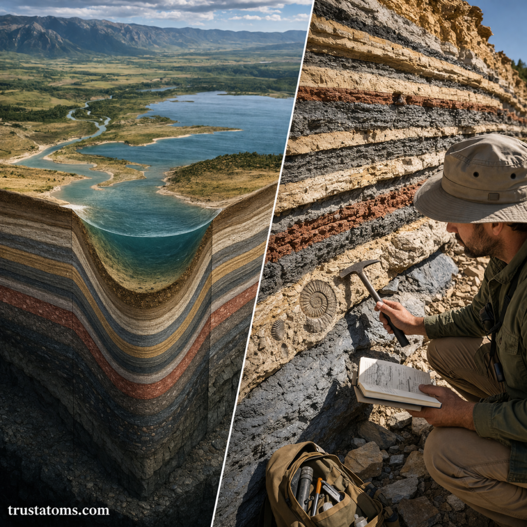
Sedimentary basins preserve deposits, while stratigraphy provides methods for interpreting their sequence and relationships. By examining how layers change across a basin, geologists can identify changes in water depth, sediment supply, tectonic activity, and environmental conditions.
Consider a simplified basin containing three layers: river sandstone at the bottom, marine shale in the middle, and shallow-water limestone above. This sequence could indicate that marine conditions gradually expanded across an area previously occupied by rivers, followed by a change in sediment supply or water depth.
Such an interpretation must be checked against fossils, sedimentary structures, and neighboring rock exposures. A single vertical sequence rarely tells the complete history of an entire basin.
What Sedimentary Layers Reveal About Past Environments
Different environments leave recognizable combinations of sediment, structures, and fossils. Geologists compare these features with modern depositional settings to interpret ancient conditions.
- Rivers: Channel-shaped sandstone bodies, gravel deposits, and cross-bedding may indicate flowing water.
- Deserts: Large-scale cross-bedded sandstone can preserve the movement of wind-blown dunes.
- Lakes: Fine mud layers, freshwater fossils, and seasonal laminations may record quiet-water deposition.
- Marine environments: Mudstone, limestone, marine fossils, and wave-generated structures can indicate different ocean conditions.
- Deltas: Alternating sand, silt, and mud may record shifting river channels and shoreline movement.
Because similar sediments can form in different settings, reliable interpretations combine multiple observations rather than relying on rock composition alone.
How Geologists Study Basins Beneath the Surface
Many sedimentary layers are buried too deeply to observe directly. Geologists therefore combine surface observations with subsurface measurements.
- Seismic reflection surveys: Use reflected sound waves to image underground rock boundaries and structures.
- Drill cores: Provide physical samples of buried rock layers for detailed examination.
- Well logs: Measure properties such as natural radioactivity and electrical resistivity to distinguish subsurface formations.
- Radiometric dating: Determines numerical ages of suitable minerals or associated volcanic layers.
- Geological mapping: Documents the distribution and orientation of exposed formations.
These techniques are used in groundwater studies, geological hazard assessment, and the exploration of resources such as petroleum, coal, and construction materials.
Why the Sedimentary Record Is Often Incomplete
Not every period of geological history leaves a preserved sedimentary layer. Deposition may stop, erosion may remove existing rock, or tectonic deformation may disrupt the original sequence.
A surface representing missing geological time is called an unconformity. Recognizing unconformities helps geologists avoid treating an incomplete rock sequence as an uninterrupted record.
Faults, folding, and changes in sediment composition can also complicate comparisons between locations. Reliable basin reconstruction requires examining the wider geological setting.
Frequently Asked Questions
What is the difference between a sedimentary basin and stratigraphy?
A sedimentary basin is a geological region where sediments accumulate. Stratigraphy is the study of rock layers, including their sequence, characteristics, and age relationships. Stratigraphic methods help interpret the deposits preserved in sedimentary basins.
Are the oldest sedimentary layers always at the bottom?
In an undisturbed sequence, older layers generally occur beneath younger layers. However, folding, faulting, or overturning can change their original positions, so geologists examine structural evidence before assigning relative ages.
Can stratigraphy determine the exact age of a rock layer?
Stratigraphy commonly establishes relative ages, showing which layers are older or younger. Numerical ages may be obtained through radiometric dating of suitable materials, such as volcanic ash layers, and then used to constrain the ages of surrounding sedimentary deposits.
Sedimentary basins preserve evidence of changing landscapes, while stratigraphy helps geologists organize that evidence into a sequence of events. By combining rock layers, fossils, sedimentary structures, and dating methods, researchers can reconstruct past environments and identify where important geological resources may occur.
Sources: U.S. Geological Survey, geological mapping and sedimentary basin resources; Boggs, Principles of Sedimentology and Stratigraphy; International Commission on Stratigraphy, International Chronostratigraphic Chart.