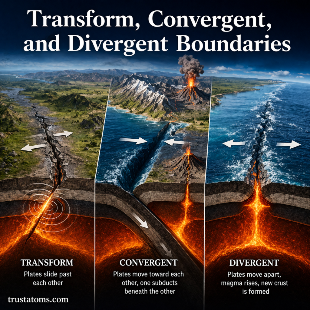
Transform, convergent, and divergent boundaries are the three main types of tectonic plate boundaries, distinguished by whether plates slide past, move toward, or move away from one another. These movements produce earthquakes, volcanic activity, mountain ranges, ocean trenches, and new oceanic crust.
Tectonic plate boundaries are where some of Earth’s most powerful geological activity occurs. Understanding their behavior is part of Earth science because plate movement connects processes inside Earth with changes visible at its surface.
What Are Tectonic Plate Boundaries?
Plate boundaries are zones where sections of Earth’s lithosphere meet and move relative to each other. The lithosphere includes the crust and rigid uppermost mantle, divided into tectonic plates that move over the weaker underlying mantle.
The Theory of Plate Tectonics explains how these moving plates account for patterns of earthquakes, volcanoes, ocean-floor formation, and mountain building.
Plate boundaries are not always single, narrow cracks. Some extend across broad zones containing numerous faults and deforming rocks. Their movement also creates risks examined in Plate Boundary Hazards, including earthquakes, volcanic eruptions, and tsunamis.
Divergent Boundaries: Where Plates Move Apart
Divergent boundaries occur where two tectonic plates move away from each other. As the plates separate, hot mantle material rises and undergoes decompression melting, producing magma that can cool into new crust.
At oceanic divergent boundaries, this process creates new seafloor along mid-ocean ridges. It is known as seafloor spreading.
Mid-Ocean Ridges and Continental Rifts
The Mid-Atlantic Ridge is a major divergent boundary running through the Atlantic Ocean. As plates separate, magma rises and solidifies, adding new oceanic crust along the ridge.
On land, divergent movement can stretch and fracture continental crust, forming rift valleys. The East African Rift is an example of a region undergoing continental extension.
Typical features of divergent boundaries include:
- Mid-ocean ridges and continental rift valleys.
- Shallow earthquakes caused by crustal extension and fault movement.
- Volcanic activity associated with rising magma.
- Formation of new oceanic crust at spreading centers.
Convergent Boundaries: Where Plates Move Together
Convergent boundaries form where tectonic plates move toward each other. The resulting geological activity depends largely on whether the interacting plates contain oceanic or continental lithosphere.
Oceanic-Continental Convergence
When an oceanic plate meets a continental plate, the denser oceanic lithosphere commonly sinks beneath the continent in a process called subduction.
Subduction creates deep ocean trenches and can generate magma that rises through the overriding plate. The Andes Mountains along western South America illustrate this combination of subduction, volcanic activity, and mountain building.
Oceanic-Oceanic Convergence
When two oceanic plates converge, one may subduct beneath the other. The descending plate releases water into the overlying mantle, promoting melting and helping produce volcanic island arcs.
Japan and the Mariana island arc are associated with oceanic subduction systems, where trenches, earthquakes, and volcanoes occur together.
Continental-Continental Convergence
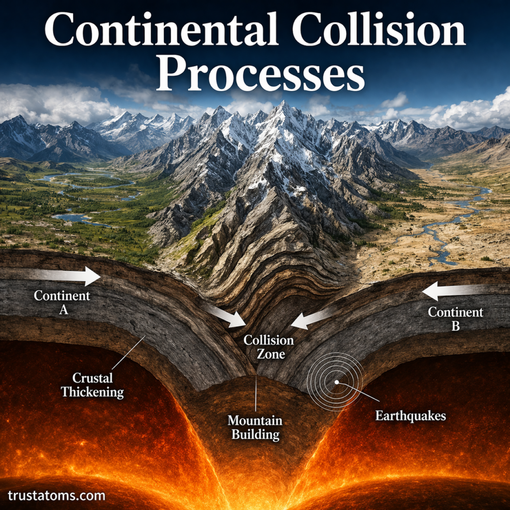
When two continents collide, their relatively buoyant continental crust resists deep subduction. Instead, crust may shorten, fold, thicken, and rise into major mountain ranges.
The Himalayas formed through the collision of the Indian and Eurasian plates. This region continues to experience tectonic deformation and powerful earthquakes.
Transform Boundaries: Where Plates Slide Past
Transform boundaries occur where tectonic plates move horizontally past one another. Unlike divergent boundaries, they do not generally create new crust, and unlike subduction zones, they do not systematically consume oceanic lithosphere.
Movement often occurs along faults where friction temporarily prevents rocks from sliding smoothly. Stress accumulates until a fault slips, releasing energy as an earthquake.
California’s San Andreas Fault system is a well-known example. It accommodates much of the horizontal motion between the Pacific and North American plates.
Transform boundaries commonly produce shallow earthquakes and elongated fault zones. Volcanoes are not generally associated with the transform motion itself, although volcanic regions can exist nearby.
Comparing Divergent, Convergent, and Transform Boundaries
| Boundary Type | Plate Movement | Common Features | Example |
|---|---|---|---|
| Divergent | Move apart | Ridges, rifts, shallow earthquakes, volcanism | Mid-Atlantic Ridge |
| Convergent | Move together | Trenches, mountains, earthquakes, often volcanism | Andes Mountains |
| Transform | Slide past | Fault zones and shallow earthquakes | San Andreas Fault |
All three boundary types can produce earthquakes, but their volcanic activity and effects on crust differ. The specific hazards also depend on local geology, plate geometry, and the rate of movement.
How Plate Boundaries Shape Earth’s Surface
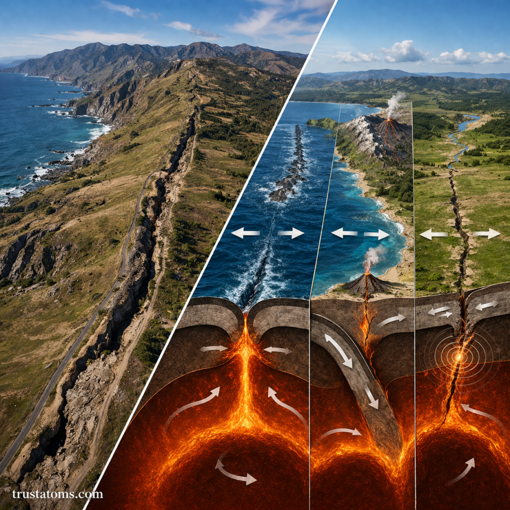
Plate movement changes the distribution of land and ocean basins. Divergent boundaries create new oceanic crust, subduction zones recycle oceanic lithosphere into the mantle, and continental collisions thicken crust into mountain belts.
These processes occur across the interconnected plate system described in Earth’s Major Tectonic Plates, including the Pacific, North American, Eurasian, African, and Antarctic plates.
Boundary processes also influence where certain mineral deposits develop. Magmatic activity, circulating hot fluids, and crustal deformation help explain why valuable resources are concentrated in some geological regions. The relationship between plate boundaries and resources is therefore useful for understanding geological exploration.
A Real-World Example: Measuring Plate Movement
Tectonic plates commonly move at rates of a few centimeters per year. A plate moving at 5 centimeters per year would travel approximately 50 meters over 1,000 years if that rate remained constant.
Although this movement is too slow to notice directly, modern GPS measurements can detect changes in ground position over time. Scientists compare measurements from stations on different plates to determine how quickly they move relative to one another.
Faults may remain locked while plates continue moving. The resulting strain can accumulate for decades or longer before being released during an earthquake, which is why slow plate motion can still produce sudden destructive events.
What Drives Tectonic Plate Movement?
Plate motion results from gravitational and mechanical forces associated with Earth’s internal heat and the behavior of the mantle. Three commonly discussed processes help explain this movement.
- Slab pull: Cold, dense oceanic lithosphere sinks into the mantle at subduction zones, helping pull the rest of the plate.
- Ridge push: Gravity contributes to plate movement away from elevated mid-ocean ridges.
- Mantle flow: Slow movement within Earth’s mantle interacts with tectonic plates and influences their motion.
Slab pull is considered a major driving force for many plates, although the relative contribution of each process varies. Plate boundaries can also change location or character as tectonic systems evolve.
Frequently Asked Questions
Which plate boundary produces the strongest earthquakes?
Convergent subduction zones can produce the largest earthquakes because enormous areas of the boundary may rupture together. Transform and continental collision boundaries can also generate highly destructive earthquakes.
Do all plate boundaries produce volcanoes?
No. Volcanic activity is common at divergent boundaries and many subduction zones. Transform boundaries generally do not produce volcanism directly, and continental collision zones may have little or no active volcanism.
Can tectonic plate boundaries change over time?
Yes. Plate boundaries can migrate, develop new faults, or become inactive as plate motions change. A region experiencing continental rifting may eventually develop an ocean basin if separation continues.
Transform, convergent, and divergent boundaries describe three different ways tectonic plates interact, each producing recognizable geological features and hazards. Comparing their movements helps explain why earthquakes cluster along faults, volcanoes form in particular regions, and mountains and ocean basins continue to change over time.
Sources: United States Geological Survey, This Dynamic Earth: The Story of Plate Tectonics; National Park Service, plate tectonics educational resources; OpenStax, Physical Geology.