Coastal Landforms and Wave Action

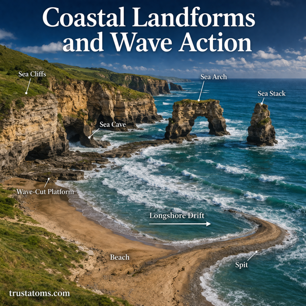
Coastal landscape illustration showing sea cliffs, sea arch, sea stack, beach, and wave action shaping the shoreline.
Wave erosion creates cliffs, caves, arches, and sea stacks, while sediment deposition builds beaches and other coastal features.

Coastal landforms develop as ocean waves erode rock, transport sediment, and deposit material along shorelines, creating features such as cliffs, sea arches, beaches, and spits. Wave action continually reshapes these features, with the results depending on rock resistance, sediment supply, wave energy, and coastal conditions.

Coastal landforms are constantly shaped and reshaped by the powerful forces of waves, tides, and currents. Along shorelines around the world, wave action can carve cliffs, form beaches, and reshape headlands. These interactions are studied in Earth science because they connect ocean movement with changes to Earth’s surface.

Continue reading “Coastal Landforms and Wave Action”
Karst Landscapes and Limestone Erosion

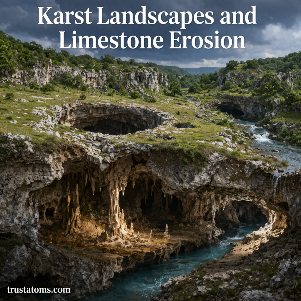
Karst landscape illustration showing sinkholes, limestone caves, underground river, and erosion processes.
Illustration of karst landscapes formed by limestone erosion, featuring caves, sinkholes, and underground water systems.

Karst landscapes form when slightly acidic water dissolves soluble bedrock, especially limestone, gradually creating caves, sinkholes, underground channels, and distinctive surface landforms. This process, known as dissolution, changes how water moves through the ground and can produce extensive drainage networks beneath the landscape.

Karst terrain is found in regions ranging from Kentucky and Florida to southern China and the Balkans. Studying these landscapes through Earth science reveals how water, rock chemistry, and geological structure interact to shape the surface and influence groundwater resources.

Continue reading “Karst Landscapes and Limestone Erosion”

Desert Landforms and Wind Erosion

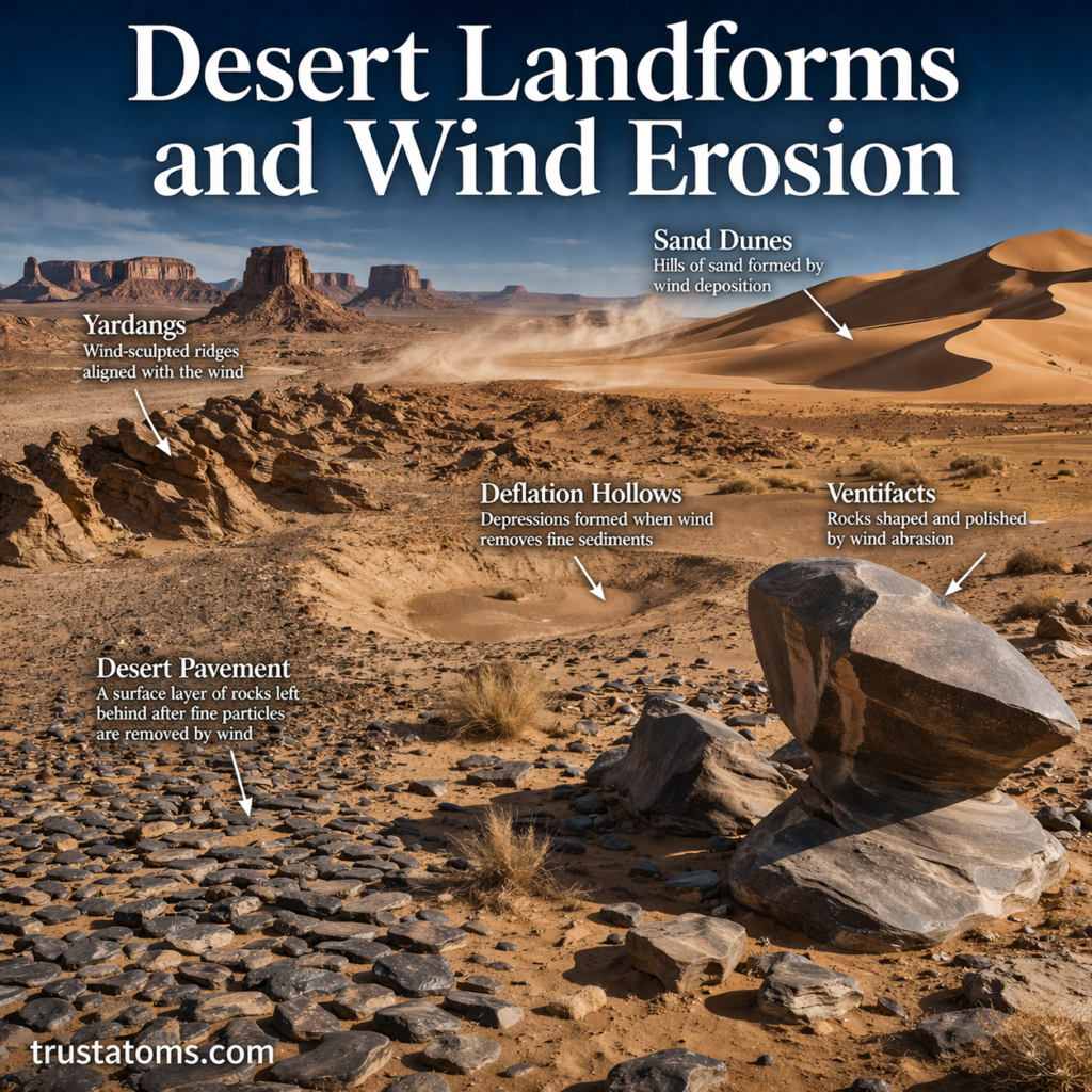
Illustration of desert landforms including sand dunes, yardangs, desert pavement, and ventifacts shaped by wind erosion.
A detailed desert landscape showing how wind erosion shapes dunes, rocks, and surface features over time.

Desert landforms develop through erosion, sediment transport, and deposition, with wind shaping features such as sand dunes, polished rocks, and streamlined ridges. Wind erosion removes loose particles from exposed surfaces, while deposited sediment builds new landforms that can shift as environmental conditions change.

Although deserts receive little rainfall, both wind and occasional flowing water reshape their landscapes. Studying these processes connects desert environments to Earth science and helps explain why some deserts contain extensive sand dunes while others consist mainly of gravel, rock, or exposed bedrock.

Continue reading “Desert Landforms and Wind Erosion”

River Systems and Valley Formation

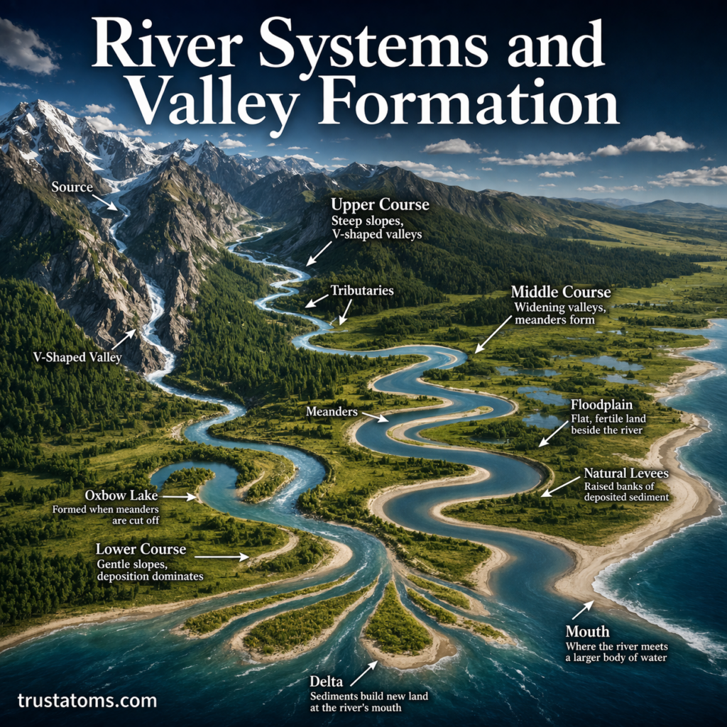
Illustration of a river system showing source, tributaries, meanders, floodplains, and delta formation across a landscape.
A detailed river system diagram showing how flowing water shapes valleys, meanders, floodplains, and deltas.

River systems form valleys by eroding rock and soil as water flows downhill, gradually cutting channels deeper and widening the surrounding landscape. As rivers transport and deposit sediment, they also create meanders, floodplains, natural levees, and deltas that change shape over time.

In Earth science, rivers demonstrate how flowing water connects the water cycle with geological change. Understanding river systems and sediment transport alongside valley formation helps explain how landscapes evolve, how ecosystems develop, and how water moves across the planet.

Continue reading “River Systems and Valley Formation”

Glacial Landforms and Ice Movement

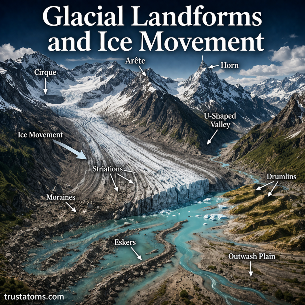
Illustration of glacial landforms including U-shaped valley, moraines, drumlins, and ice movement through a mountain landscape.
Moving glacier ice erodes mountain valleys and transports sediment that can form moraines, drumlins, and other distinctive landforms.

Glacial landforms are landscape features created when moving glacier ice erodes rock, transports sediment, and deposits material as the ice melts or retreats. Glaciers move under gravity through the slow deformation of ice and, in many cases, sliding over the ground, gradually carving valleys and reshaping mountains and plains.

These processes leave recognizable evidence of former ice coverage, including U-shaped valleys, scratched bedrock, and ridges of rocky debris. Studying glacial landscapes is part of Earth science, helping researchers reconstruct past environments and understand how ice continues to change Earth’s surface.

Continue reading “Glacial Landforms and Ice Movement”

Folding and Faulting in Earth’s Crust

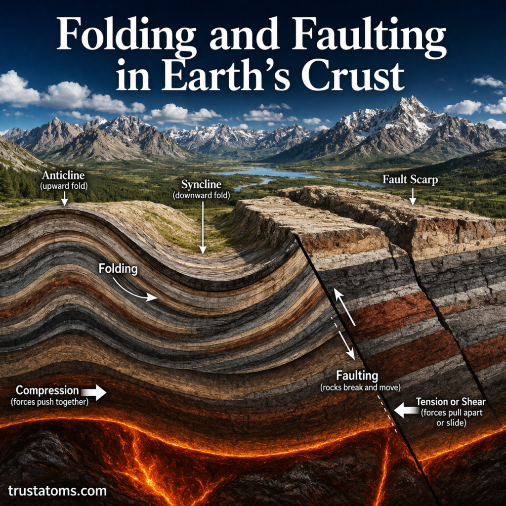
Illustration showing folded rock layers and fault lines demonstrating folding and faulting processes in Earth’s crust.
A geological cross-section illustrating how folding bends rock layers and faulting breaks and shifts the crust.

Folding and faulting are two ways Earth’s crust deforms under tectonic forces: folding bends rock layers, while faulting fractures rocks and moves them along a break. Both processes help form mountains, valleys, and other geological structures, but they involve different responses to stress.

These changes are part of Earth science, which examines how the planet’s systems interact and reshape its surface. Folding and faulting have shaped many of the landscapes we see today. They also play a major role in earthquakes and the overall structure of Earth’s surface.

Continue reading “Folding and Faulting in Earth’s Crust”

Continental Collision Processes

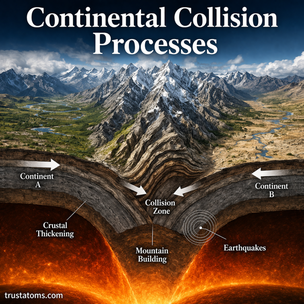
Illustration of continental collision showing two tectonic plates converging and forming mountains through crustal thickening.
Continental collision compresses and thickens Earth’s crust, producing uplifted mountain ranges and deep crustal roots.

Continental collision occurs when two masses of continental crust converge, compressing and thickening the crust to form mountain ranges, high plateaus, and major fault systems. Because continental crust is relatively buoyant, neither continent readily sinks deep into the mantle, so much of the convergence is accommodated by folding, faulting, and uplift.

These processes reshape entire regions over millions of years and continue in active mountain belts such as the Himalayas. Understanding continental collision is part of Earth science, connecting plate tectonics with earthquakes, rock deformation, mountain formation, and changes to Earth’s landscape.

Continue reading “Continental Collision Processes”

Earth’s Major Tectonic Plates

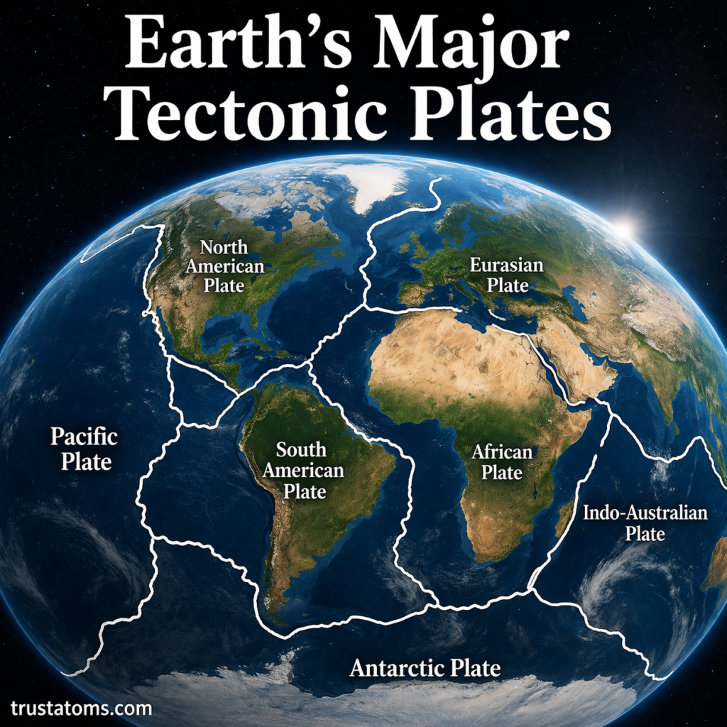
Illustration of Earth’s major tectonic plates labeled on a global map showing plate boundaries and continents.
Earth’s major tectonic plates cover the planet’s surface and interact along boundaries where earthquakes, mountain building, and volcanic activity commonly occur.

Earth’s surface is divided into seven commonly recognized major tectonic plates: the Pacific, North American, South American, Eurasian, African, Antarctic, and Indo-Australian plates. These enormous sections of Earth’s rigid outer shell move slowly relative to one another, reshaping continents, ocean basins, mountain ranges, and zones of earthquake and volcanic activity.

Earth’s surface may look solid and unchanging, but it is actually broken into massive pieces called tectonic plates. These plates are constantly moving—albeit very slowly—shaping the continents, oceans, mountains, and even influencing earthquakes and volcanic activity.

Understanding these movements is a central part of Earth science. Plate maps help scientists explain why earthquakes cluster in particular regions, why mountain ranges form, and how the positions of continents have changed throughout geological history.

Continue reading “Earth’s Major Tectonic Plates”

Hotspots and Mantle Plumes

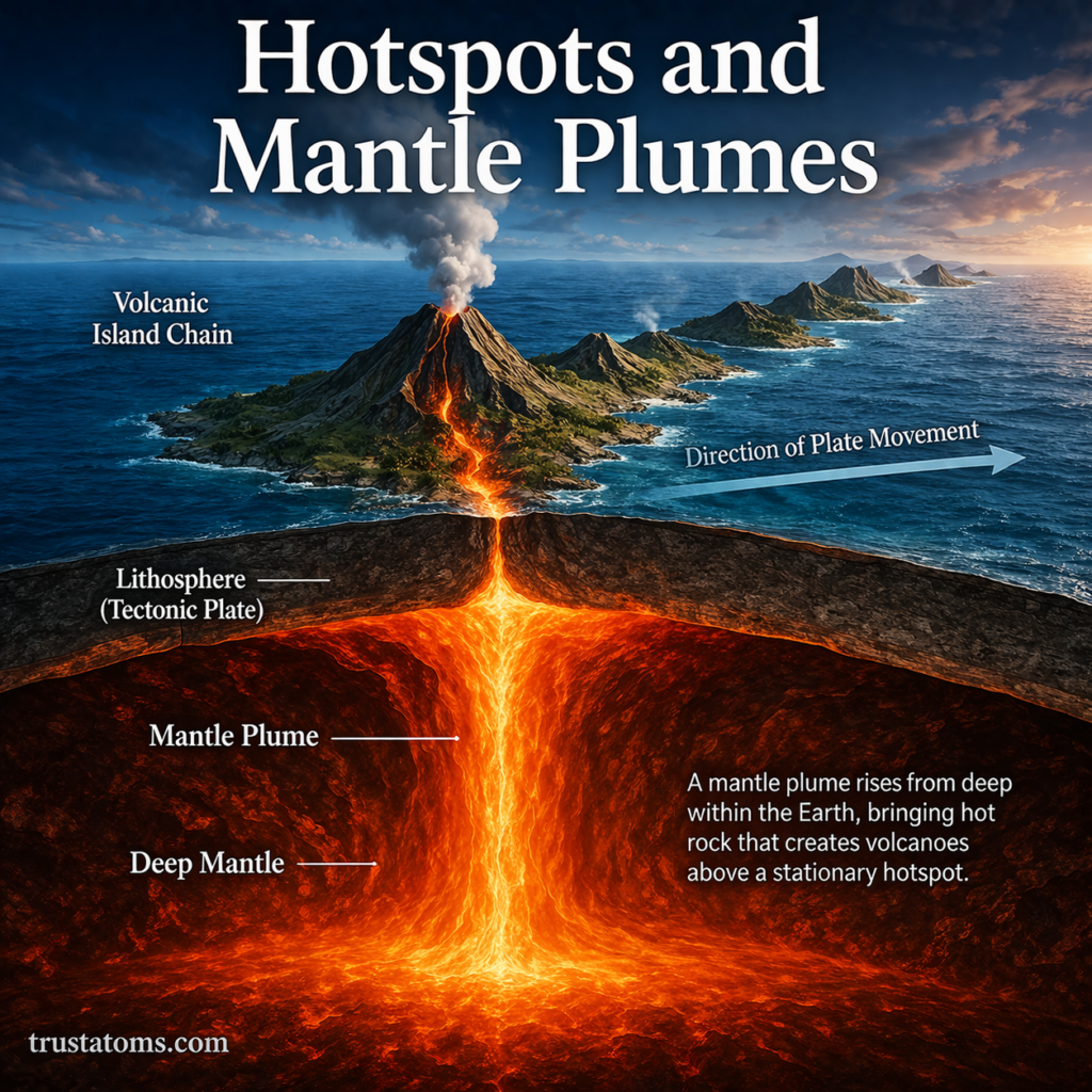
Illustration showing mantle plume rising beneath a tectonic plate forming a hotspot and volcanic island chain.
A mantle plume may supply hot rock beneath a tectonic plate, producing volcanoes that form a chain as the plate moves over the hotspot.

Hotspots are regions of persistent volcanic activity often found away from tectonic plate boundaries, while mantle plumes are proposed upwellings of unusually hot rock that can supply the heat responsible for some hotspots. As a tectonic plate moves over a relatively long-lived hotspot, successive volcanoes may form, creating island chains such as Hawaii.

Hotspots provide scientists with clues about Earth’s interior, volcanic activity, and plate movement. Studying these features connects mantle processes with surface geology, making them an important topic in Earth science. Although mantle plumes explain many observations, scientists continue investigating whether every hotspot has the same deep origin.

Continue reading “Hotspots and Mantle Plumes”

Ocean Trenches and Deep-Sea Topography

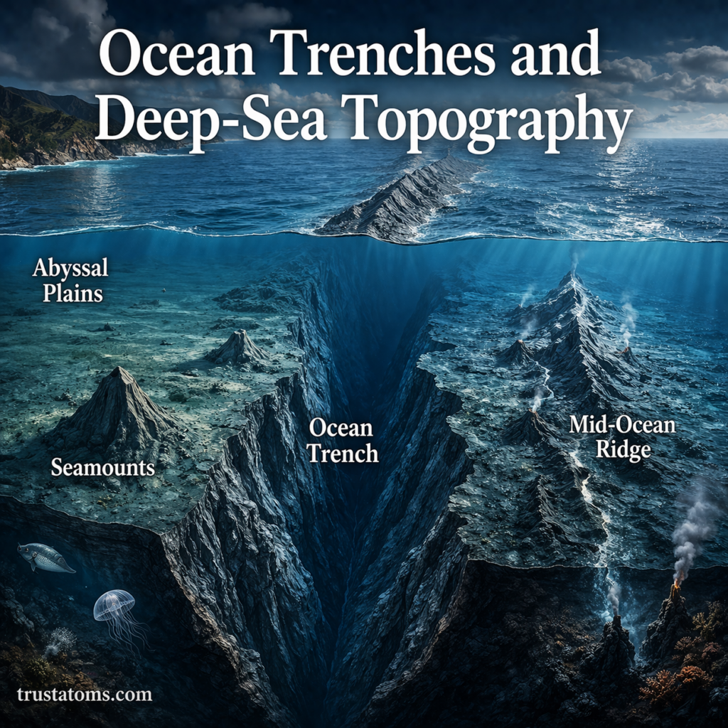
Illustration of ocean trenches and deep-sea topography showing abyssal plains, seamounts, and mid-ocean ridges beneath the ocean surface.
The ocean floor contains deep trenches, broad abyssal plains, volcanic seamounts, and extensive mid-ocean ridge systems.

Ocean trenches are long, narrow depressions in the seafloor that form mainly where one tectonic plate bends and sinks beneath another. They are part of deep-sea topography, which also includes underwater mountain ranges, broad plains, volcanic seamounts, and other features shaped by plate movement and sediment deposition.

Although hidden beneath kilometers of seawater, these landscapes provide evidence of how Earth’s crust forms, moves, and is recycled. Studying them is an important part of Earth science, connecting seafloor geology with earthquakes, volcanism, ocean circulation, and deep-sea ecosystems.

Continue reading “Ocean Trenches and Deep-Sea Topography”