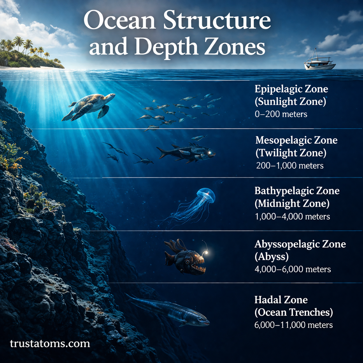
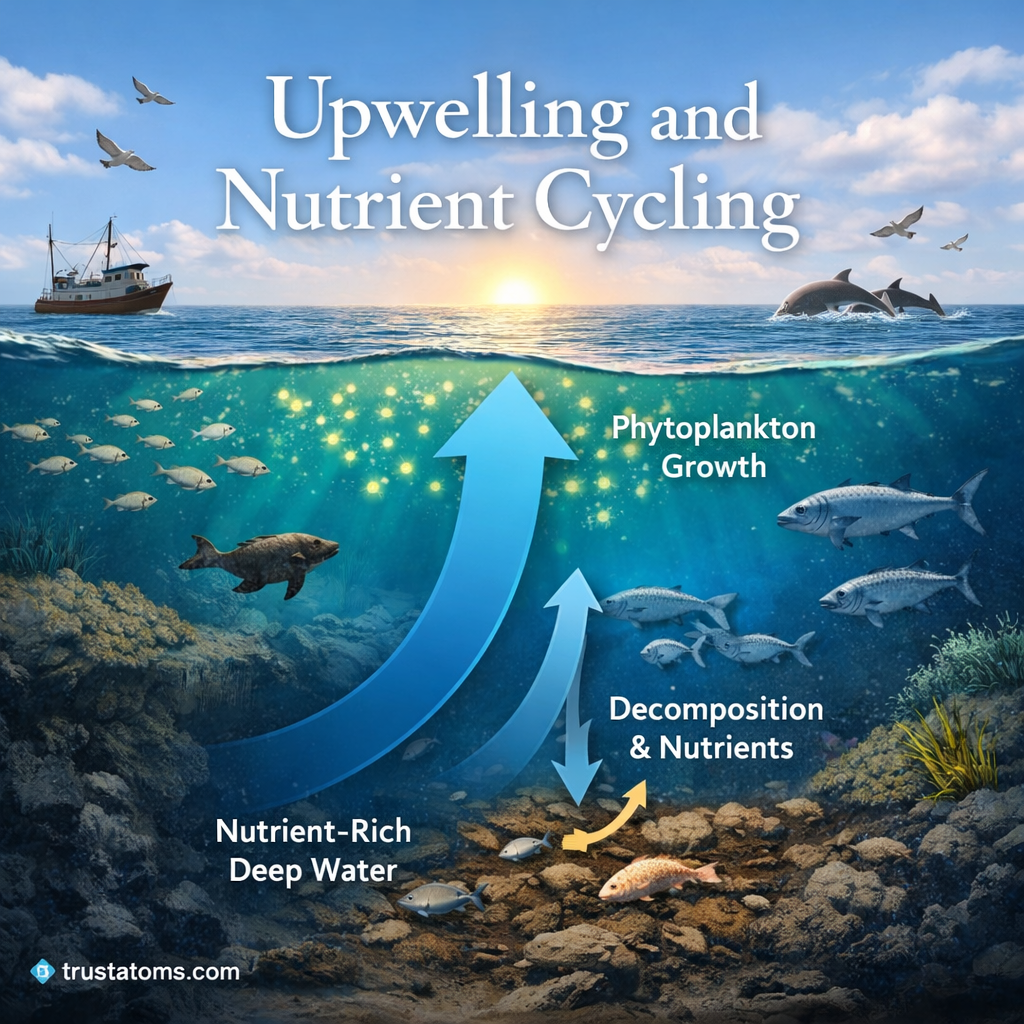
Microclimates and Local Weather Variation

Illustration showing different microclimates including a cool coastal area, warm urban city, and a moist mountainous region.
Illustration of microclimates showing how coastal, urban, and mountainous areas experience different local weather conditions. trustatoms.com.

Weather can vary dramatically over short distances—even within the same city or neighborhood. These localized differences are known as microclimates, and they play an important role in shaping everyday weather conditions.

From cooler coastal breezes to warmer urban centers, microclimates explain why two nearby areas can experience very different temperatures, humidity levels, and weather patterns at the same time.

Continue reading “Microclimates and Local Weather Variation”

Dust Storms and Arid Climate Systems

Illustration of a large dust storm sweeping across a dry desert landscape with sparse vegetation and arid conditions.
Illustration of dust storms in arid climates showing how dry land and strong winds create massive airborne dust clouds. trustatoms.com.

Dust storms are powerful natural events that can transform clear skies into dense clouds of airborne particles within minutes. Common in dry and desert regions, these storms are closely tied to arid climate systems, where limited moisture, loose soil, and strong winds create ideal conditions for dust to be lifted into the atmosphere.

Understanding how dust storms form and why they are so common in arid regions helps explain their environmental impact and global significance.

Continue reading “Dust Storms and Arid Climate Systems”

Heat Waves and Atmospheric Blocking

Illustration showing a heat wave caused by atmospheric blocking with a high-pressure system trapping hot air over a city.
Illustration of heat waves and atmospheric blocking showing how high-pressure systems trap heat and intensify temperatures. trustatoms.com.

Heat waves are among the most impactful and dangerous weather events, often lasting for days or even weeks. While high temperatures alone can occur for short periods, prolonged and extreme heat is usually linked to a specific atmospheric pattern known as atmospheric blocking.

Understanding how heat waves form—and why they sometimes persist—helps explain their intensity, duration, and growing impact on communities around the world.

Continue reading “Heat Waves and Atmospheric Blocking”

Snow Formation and Winter Storms

Illustration showing snow formation process from water vapor to snowflakes and a winter storm impacting a snowy town.
Illustration of snow formation and winter storms showing how ice crystals develop and snowfall impacts the environment. trustatoms.com.

Snow is one of the most recognizable features of winter weather, yet its formation involves a complex interaction of temperature, moisture, and atmospheric dynamics. From light flurries to powerful blizzards, snowstorms are driven by specific conditions in the atmosphere.

Understanding how snow forms and how winter storms develop helps explain why some regions experience heavy snowfall while others remain dry and cold.

Continue reading “Snow Formation and Winter Storms”

Atmospheric Moisture and Humidity

Illustration showing atmospheric moisture processes including evaporation, water vapor, condensation, and humidity in the atmosphere.
Illustration of atmospheric moisture and humidity showing evaporation, condensation, and water vapor movement. trustatoms.com.

Atmospheric moisture plays a key role in weather, climate, and everyday comfort. Whether it’s a humid summer day or a dry winter morning, the amount of water vapor in the air directly affects how we feel and how the atmosphere behaves.

Understanding humidity helps explain everything from cloud formation to precipitation—and even why some days feel hotter than they actually are.

Continue reading “Atmospheric Moisture and Humidity”

Polar Vortex and Cold Air Movement

Illustration showing the polar vortex over the Arctic with cold air moving south and the jet stream guiding temperature patterns.
Illustration of the polar vortex and how cold Arctic air moves south through jet stream patterns. trustatoms.com.

The term “polar vortex” often makes headlines during extreme winter weather—but what does it actually mean?

Despite how it’s portrayed, the polar vortex isn’t a sudden storm or a new phenomenon. It’s a large-scale atmospheric feature that plays a major role in how cold air moves across the Northern Hemisphere.

Understanding how it works helps explain why some winters bring mild conditions while others deliver intense cold outbreaks.

Continue reading “Polar Vortex and Cold Air Movement”

Temperature Gradients in the Atmosphere

Temperature gradients in the atmosphere diagram showing atmospheric layers and how temperature changes with altitude.
Illustration of atmospheric layers and how temperature increases or decreases with altitude. trustatoms.com.

Temperature in the atmosphere does not remain constant—it changes with altitude, location, and time. These changes, known as temperature gradients, play a critical role in weather patterns, atmospheric stability, and energy transfer across the planet.

Understanding temperature gradients helps explain why storms form, how air moves, and why different layers of the atmosphere behave the way they do.

Continue reading “Temperature Gradients in the Atmosphere”

Wind Patterns and Surface Circulation

Wind patterns and surface circulation diagram showing global wind belts, pressure systems, and jet streams around Earth.
Illustration of global wind patterns, pressure systems, and atmospheric circulation across Earth. trustatoms.com.

Wind is the movement of air across Earth’s surface, driven by differences in temperature and pressure. These movements create recognizable global wind patterns and surface circulation systems that influence weather, climate, and ocean currents.

Understanding wind patterns helps explain everything from daily weather changes to long-term climate zones across the planet.

Continue reading “Wind Patterns and Surface Circulation”

Radar and Satellite Weather Observation

Radar and satellite weather observation illustration showing weather radar tower, satellite monitoring Earth, and storm tracking systems.
Visualization of radar and satellite systems used to monitor storms and atmospheric conditions. trustatoms.com.

Modern weather forecasting relies heavily on advanced observation systems. Among the most important tools are radar and satellite technologies, which allow meteorologists to monitor the atmosphere in real time.

These systems provide critical data on storms, clouds, precipitation, and large-scale weather patterns—helping improve forecast accuracy and early warning systems.

Continue reading “Radar and Satellite Weather Observation”

Weather Forecasting Methods and Models

Weather forecasting methods and models illustration showing satellites, radar, weather stations, and forecast maps.
Overview of modern weather forecasting tools including satellites, radar systems, and computer models. trustatoms.com.

Weather forecasting is the science of predicting atmospheric conditions at a specific time and place. From daily temperature forecasts to severe storm warnings, modern forecasting combines observation, physics, and advanced computer models to provide accurate predictions.

Understanding how forecasts are made helps explain why they are sometimes highly accurate—and other times uncertain.

Continue reading “Weather Forecasting Methods and Models”